Champeaux geodata
Champeaux (Île-de-France) is a populated place; located in France in Europe/Paris (GMT+2) time zone. With population of 882 people, there are 9803 cities with bigger population in this country. Compared to other cities in France, 70.5% of cities are located further ↓South; 55% of cities are located further ←West and 61.2% of cities have higher elevation than Champeaux. Note1
Administrative division(s):
- Level 1: Île-de-France
- Level 2: Seine-et-Marne
- Level 3: Arrondissement de Melun
- Level 4: Champeaux


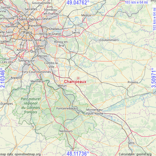
Champeaux GPS coordinates[2]
48° 35' 4.668" North, 2° 48' 23.688" East
| Map corner | latitude | longitude |
|---|---|---|
| Upper-left | 49.04762°, | 2.10346° |
| Center: | 48.58463°, | 2.80658° |
| Lower-right: | 48.11736°, | 3.50971° |
| Map W x H: | 103.4×103.4 km | = 64.2×64.2mi |
| max Lat: | 51.07786° ⇑29.5% North |
| Champeaux: | 48.58463° |
| min Lat: | ⇓70.5% South 41.3874° |
| min Long | Champeaux | max Long |
| -5.08615° | 2.80658° | 9.52242° |
| W 55%⇐ | ⇒45% E |
Elevation
Elevation of Champeaux is 99 m = 325 ft, and this is 94.7 m = 311 ft below average elevation for this country.
| Max E: |
2333 m = 7654 ft | 61.2% |
| Avg. | 193.7 m = 635 ft | |
| Champeaux | 99 m = 325 ft | |
Min E: |
-1 m = -3 ft | 38.8% |
See also: France elevation on elevation.city.
Geographical zone
Champeaux is located in North temperate zone (between Tropic of Cancer and the Arctic Circle). Distance of this North polar circle is 1999.1 km =1242.2 mi to North.| Distance of | km | miles | from Champeaux |
|---|---|---|---|
| North Pole | 4605 | 2861.4 | to North |
| Arctic Circle | 1999.1 | 1242.2 | to North |
| Tropic Cancer | 2796.2 | 1737.5 | to South |
| Equator | 5402.1 | 3356.7 | to South |


Nearby cities:
15 places around Champeaux: (largest is in red/bold)
• Aubepierre-Ozouer-le-Repos
7.8 km =4.8 mi,  46°
46°
• Blandy
2.7 km =1.7 mi,  223°
223°
• Bombon
4.2 km =2.6 mi,  109°
109°
• Champdeuil
7 km =4.3 mi,  304°
304°
• Crisenoy
4.9 km =3 mi,  284°
284°
• Fouju
2.1 km =1.3 mi,  273°
273°
• Guignes
5.4 km =3.4 mi,  354°
354°
• La Chapelle-Gauthier
7.8 km =4.8 mi,  120°
120°
• Le Châtelet-en-Brie
8.7 km =5.4 mi,  187°
187°
• Maincy
8.7 km =5.4 mi,  243°
243°
• Moisenay
5.8 km =3.6 mi,  245°
245°
• Mormant
6.7 km =4.2 mi,  66°
66°
• Saint-Germain-Laxis
7.1 km =4.4 mi, 267°
• Sivry-Courtry
7.3 km =4.5 mi,  211°
211°
• Yèbles
6.4 km =4 mi,  333°
333°
Sources, notices
• [Note1] Compared only with cities in France existing in our database
• [Src1] Map data: © OpenStreetMap contributors (CC-BY-SA)
• [Src2] Other city data from geonames.org with taken over terms of usage.
• [Src3] Geographical zone / Annual Mean Temperature by Robert A. Rohde @ Wikipedia
