Crancey geodata
Crancey (Grand Est) is a populated place; located in France in Europe/Paris (GMT+2) time zone. With population of 856 people, there are 10023 cities with bigger population in this country. Compared to other cities in France, 68.7% of cities are located further ↓South; 65.3% of cities are located further ←West and 75.4% of cities have higher elevation than Crancey. Note1
Administrative division(s):
- Level 1: Grand Est
- Level 2: Département de l'Aube
- Level 3: Arrondissement de Nogent-sur-Seine
- Level 4: Crancey


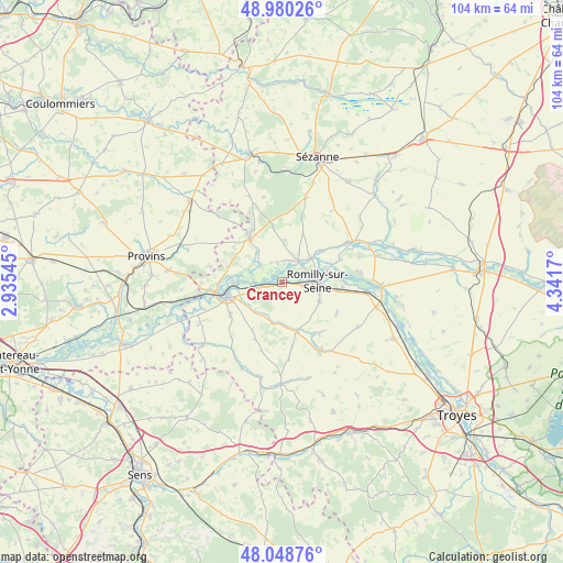
Crancey GPS coordinates[2]
48° 30' 59.94" North, 3° 38' 18.888" East
| Map corner | latitude | longitude |
|---|---|---|
| Upper-left | 48.98026°, | 2.93545° |
| Center: | 48.51665°, | 3.63858° |
| Lower-right: | 48.04876°, | 4.3417° |
| Map W x H: | 103.6×103.6 km | = 64.4×64.4mi |
| max Lat: | 51.07786° ⇑31.3% North |
| Crancey: | 48.51665° |
| min Lat: | ⇓68.7% South 41.3874° |
| min Long | Crancey | max Long |
| -5.08615° | 3.63858° | 9.52242° |
| W 65.3%⇐ | ⇒34.7% E |
Elevation
Elevation of Crancey is 66 m = 217 ft, and this is 127.7 m = 419 ft below average elevation for this country.
| Max E: |
2333 m = 7654 ft | 75.4% |
| Avg. | 193.7 m = 635 ft | |
| Crancey | 66 m = 217 ft | |
Min E: |
-1 m = -3 ft | 24.6% |
See also: France elevation on elevation.city.
Geographical zone
Crancey is located in North temperate zone (between Tropic of Cancer and the Arctic Circle). Distance of this North polar circle is 2006.6 km =1246.8 mi to North.| Distance of | km | miles | from Crancey |
|---|---|---|---|
| North Pole | 4612.5 | 2866.1 | to North |
| Arctic Circle | 2006.6 | 1246.8 | to North |
| Tropic Cancer | 2788.6 | 1732.8 | to South |
| Equator | 5394.5 | 3352 | to South |


Nearby cities:
15 places around Crancey: (largest is in red/bold)
• Chalautre-la-Grande
13.4 km =8.3 mi,  281°
281°
• Conflans-sur-Seine
5 km =3.1 mi,  37°
37°
• Esclavolles-Lurey
4.2 km =2.6 mi,  17°
17°
• Gélannes
4.4 km =2.7 mi,  144°
144°
• Maizières-la-Grande-Paroisse
10.9 km =6.8 mi,  93°
93°
• Marcilly-sur-Seine
6.9 km =4.3 mi,  48°
48°
• Nogent-sur-Seine
10.3 km =6.4 mi,  255°
255°
• Origny-le-Sec
11.5 km =7.1 mi,  119°
119°
• Ossey-les-Trois-Maisons
11.8 km =7.3 mi, 139°
• Pars-lès-Romilly
7.6 km =4.7 mi, 116°
• Pont-sur-Seine
3.1 km =1.9 mi,  271°
271°
• Romilly-sur-Seine
6.5 km =4 mi,  95°
95°
• Saint-Aubin
7.5 km =4.7 mi,  232°
232°
• Saint-Just-Sauvage
11.5 km =7.1 mi,  68°
68°
• Villenauxe-la-Grande
9.9 km =6.2 mi,  318°
318°
Sources, notices
• [Note1] Compared only with cities in France existing in our database
• [Src1] Map data: © OpenStreetMap contributors (CC-BY-SA)
• [Src2] Other city data from geonames.org with taken over terms of usage.
• [Src3] Geographical zone / Annual Mean Temperature by Robert A. Rohde @ Wikipedia
