Moyaux geodata
Moyaux (Normandy) is a populated place; located in France in Europe/Paris (GMT+2) time zone. With population of 1,294 people, there are 7062 cities with bigger population in this country. Compared to other cities in France, 84.2% of cities are located further ↓South; 74.8% of cities are located further →East and 57.1% of cities have lower elevation than Moyaux. Note1
Administrative division(s):
- Level 1: Normandy
- Level 2: Calvados
- Level 3: Arrondissement de Lisieux
- Level 4: Moyaux


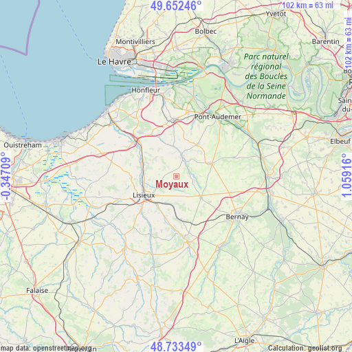
Moyaux GPS coordinates[2]
49° 11' 42.396" North, 0° 21' 21.708" East
| Map corner | latitude | longitude |
|---|---|---|
| Upper-left | 49.65246°, | -0.34709° |
| Center: | 49.19511°, | 0.35603° |
| Lower-right: | 48.73349°, | 1.05916° |
| Map W x H: | 102.2×102.2 km | = 63.5×63.5mi |
| max Lat: | 51.07786° ⇑15.8% North |
| Moyaux: | 49.19511° |
| min Lat: | ⇓84.2% South 41.3874° |
| min Long | Moyaux | max Long |
| -5.08615° | 0.35603° | 9.52242° |
| W 25.2%⇐ | ⇒74.8% E |
Elevation
Elevation of Moyaux is 158 m = 518 ft, and this is 35.7 m = 117 ft below average elevation for this country.
| Max E: |
2333 m = 7654 ft | 42.9% |
| Avg. | 193.7 m = 635 ft | |
| Moyaux | 158 m = 518 ft | |
Min E: |
-1 m = -3 ft | 57.1% |
See also: France elevation on elevation.city.
Geographical zone
Moyaux is located in North temperate zone (between Tropic of Cancer and the Arctic Circle). Distance of this North polar circle is 1931.2 km =1200 mi to North.| Distance of | km | miles | from Moyaux |
|---|---|---|---|
| North Pole | 4537.1 | 2819.2 | to North |
| Arctic Circle | 1931.2 | 1200 | to North |
| Tropic Cancer | 2864.1 | 1779.7 | to South |
| Equator | 5470 | 3398.9 | to South |


Nearby cities:
15 places around Moyaux: (largest is in red/bold)
• Beuvillers
10.3 km =6.4 mi,  225°
225°
• Blangy-le-Château
8 km =5 mi,  311°
311°
• Bonneville-la-Louvet
8.7 km =5.4 mi,  348°
348°
• Coquainvilliers
10.6 km =6.6 mi,  271°
271°
• Cormeilles
6.1 km =3.8 mi,  14°
14°
• Courtonne-la-Meurdrac
8.2 km =5.1 mi,  198°
198°
• Glos
9.8 km =6.1 mi,  213°
213°
• Hermival-les-Vaux
6.2 km =3.9 mi,  241°
241°
• Le Breuil-en-Auge
10.2 km =6.3 mi,  291°
291°
• Le Pin
2.4 km =1.5 mi,  318°
318°
• Lisieux
10.7 km =6.6 mi, 239°
• Marolles
6.4 km =4 mi,  169°
169°
• Ouilly-le-Vicomte
9.8 km =6.1 mi,  261°
261°
• Saint-Philbert-des-Champs
5.5 km =3.4 mi, 285°
• Thiberville
9.6 km =6 mi,  131°
131°
Sources, notices
• [Note1] Compared only with cities in France existing in our database
• [Src1] Map data: © OpenStreetMap contributors (CC-BY-SA)
• [Src2] Other city data from geonames.org with taken over terms of usage.
• [Src3] Geographical zone / Annual Mean Temperature by Robert A. Rohde @ Wikipedia
