Tour-en-Sologne geodata
Tour-en-Sologne (Centre) is a populated place; located in France in Europe/Paris (GMT+2) time zone. With population of 924 people, there are 9438 cities with bigger population in this country. Compared to other cities in France, 51.8% of cities are located further ↓South; 62.9% of cities are located further →East and 69.2% of cities have higher elevation than Tour-en-Sologne. Note1
Administrative division(s):
- Level 1: Centre
- Level 2: Département du Loir-et-Cher
- Level 3: Arrondissement de Blois
- Level 4: Tour-en-Sologne


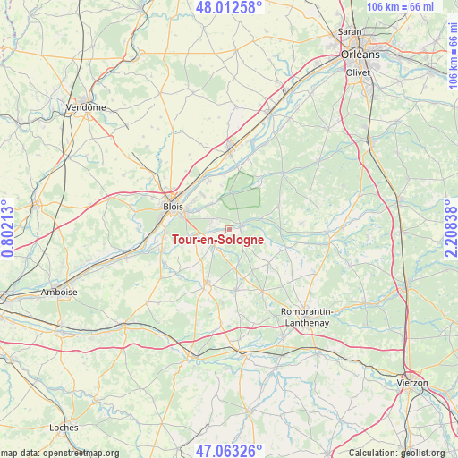
Tour-en-Sologne GPS coordinates[2]
47° 32' 24.252" North, 1° 30' 18.9" East
| Map corner | latitude | longitude |
|---|---|---|
| Upper-left | 48.01258°, | 0.80213° |
| Center: | 47.54007°, | 1.50525° |
| Lower-right: | 47.06326°, | 2.20838° |
| Map W x H: | 105.6×105.6 km | = 65.6×65.6mi |
| max Lat: | 51.07786° ⇑48.2% North |
| Tour-en-Sologne: | 47.54007° |
| min Lat: | ⇓51.8% South 41.3874° |
| min Long | Tour-en-Sologne | max Long |
| -5.08615° | 1.50525° | 9.52242° |
| W 37.1%⇐ | ⇒62.9% E |
Elevation
Elevation of Tour-en-Sologne is 80 m = 262 ft, and this is 113.7 m = 373 ft below average elevation for this country.
| Max E: |
2333 m = 7654 ft | 69.2% |
| Avg. | 193.7 m = 635 ft | |
| Tour-en-Sologne | 80 m = 262 ft | |
Min E: |
-1 m = -3 ft | 30.8% |
See also: France elevation on elevation.city.
Geographical zone
Tour-en-Sologne is located in North temperate zone (between Tropic of Cancer and the Arctic Circle). Distance of this North polar circle is 2115.2 km =1314.3 mi to North.| Distance of | km | miles | from Tour-en-Sologne |
|---|---|---|---|
| North Pole | 4721.1 | 2933.6 | to North |
| Arctic Circle | 2115.2 | 1314.3 | to North |
| Tropic Cancer | 2680 | 1665.3 | to South |
| Equator | 5286 | 3284.6 | to South |


Nearby cities:
15 places around Tour-en-Sologne: (largest is in red/bold)
• Bracieux
2.9 km =1.8 mi,  69°
69°
• Cellettes
9.4 km =5.8 mi,  261°
261°
• Cheverny
5.6 km =3.5 mi,  218°
218°
• Chitenay
11.1 km =6.9 mi,  244°
244°
• Cormeray
9.2 km =5.7 mi,  234°
234°
• Cour-Cheverny
5 km =3.1 mi, 228°
• Dhuizon
12.6 km =7.8 mi, 65°
• Fontaines-en-Sologne
4.8 km =3 mi,  135°
135°
• Huisseau-sur-Cosson
7.1 km =4.4 mi,  326°
326°
• Maslives
10.6 km =6.6 mi,  349°
349°
• Mont-près-Chambord
4.4 km =2.7 mi,  304°
304°
• Montlivault
12 km =7.5 mi,  337°
337°
• Saint-Claude-de-Diray
10.7 km =6.6 mi,  322°
322°
• Saint-Gervais-la-Forêt
11.7 km =7.3 mi,  284°
284°
• Vineuil
10.8 km =6.7 mi, 296°
Sources, notices
• [Note1] Compared only with cities in France existing in our database
• [Src1] Map data: © OpenStreetMap contributors (CC-BY-SA)
• [Src2] Other city data from geonames.org with taken over terms of usage.
• [Src3] Geographical zone / Annual Mean Temperature by Robert A. Rohde @ Wikipedia
