Couffé geodata
Couffé (Pays de la Loire) is a populated place; located in France in Europe/Paris (GMT+2) time zone. With population of 1,936 people, there are 4948 cities with bigger population in this country. Compared to other cities in France, 50.2% of cities are located further ↑North; 90.7% of cities are located further →East and 91.2% of cities have higher elevation than Couffé. Note1
Administrative division(s):
- Level 1: Pays de la Loire
- Level 2: Loire-Atlantique
- Level 3: Arrondissement of Châteaubriant-Ancenis
- Level 4: Couffé


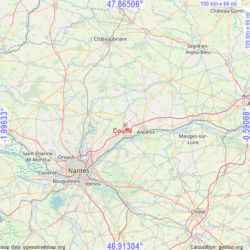
Couffé GPS coordinates[2]
47° 23' 28.32" North, 1° 17' 35.556" West
| Map corner | latitude | longitude |
|---|---|---|
| Upper-left | 47.86506°, | -1.99633° |
| Center: | 47.3912°, | -1.29321° |
| Lower-right: | 46.91304°, | -0.59008° |
| Map W x H: | 105.9×105.9 km | = 65.8×65.8mi |
| max Lat: | 51.07786° ⇑50.2% North |
| Couffé: | 47.3912° |
| min Lat: | ⇓49.8% South 41.3874° |
| min Long | Couffé | max Long |
| -5.08615° | -1.29321° | 9.52242° |
| W 9.3%⇐ | ⇒90.7% E |
Elevation
Elevation of Couffé is 27 m = 89 ft, and this is 166.7 m = 547 ft below average elevation for this country.
| Max E: |
2333 m = 7654 ft | 91.2% |
| Avg. | 193.7 m = 635 ft | |
| Couffé | 27 m = 89 ft | |
Min E: |
-1 m = -3 ft | 8.8% |
See also: France elevation on elevation.city.
Geographical zone
Couffé is located in North temperate zone (between Tropic of Cancer and the Arctic Circle). Distance of this North polar circle is 2131.8 km =1324.6 mi to North.| Distance of | km | miles | from Couffé |
|---|---|---|---|
| North Pole | 4737.7 | 2943.9 | to North |
| Arctic Circle | 2131.8 | 1324.6 | to North |
| Tropic Cancer | 2663.5 | 1655 | to South |
| Equator | 5269.4 | 3274.3 | to South |


Nearby cities:
15 places around Couffé: (largest is in red/bold)
• Ancenis
9.9 km =6.2 mi,  105°
105°
• Champtoceaux
6.7 km =4.2 mi,  159°
159°
• Drain
8.9 km =5.5 mi,  133°
133°
• La Varenne
9.1 km =5.7 mi,  192°
192°
• Le Cellier
8.9 km =5.5 mi,  206°
206°
• Ligné
6.7 km =4.2 mi,  289°
289°
• Liré
11 km =6.8 mi,  118°
118°
• Mouzeil
7.5 km =4.7 mi,  326°
326°
• Mésanger
6.6 km =4.1 mi,  47°
47°
• Oudon
4.9 km =3 mi,  172°
172°
• Pannecé
11.3 km =7 mi,  21°
21°
• Saint-Géréon
7.3 km =4.5 mi, 110°
• Saint-Mars-du-Désert
9 km =5.6 mi,  251°
251°
• Teillé
7.9 km =4.9 mi,  8°
8°
• Trans-sur-Erdre
11.3 km =7 mi, 327°
Sources, notices
• [Note1] Compared only with cities in France existing in our database
• [Src1] Map data: © OpenStreetMap contributors (CC-BY-SA)
• [Src2] Other city data from geonames.org with taken over terms of usage.
• [Src3] Geographical zone / Annual Mean Temperature by Robert A. Rohde @ Wikipedia
