Ancenis geodata
Ancenis (Pays de la Loire) is a seat of a third-order administrative division; located in France in Europe/Paris (GMT+2) time zone. With population of 7,840 people, there are 1237 cities with bigger population in this country. Compared to other cities in France, 50.5% of cities are located further ↑North; 89.7% of cities are located further →East and 98.6% of cities have higher elevation than Ancenis. Note1
Administrative division(s):
- Level 1: Pays de la Loire
- Level 2: Loire-Atlantique
- Level 3: Arrondissement of Châteaubriant-Ancenis
- Level 4: Ancenis-Saint-Géréon


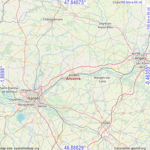
Ancenis GPS coordinates[2]
47° 22' 0.012" North, 1° 10' 0.012" West
| Map corner | latitude | longitude |
|---|---|---|
| Upper-left | 47.84075°, | -1.8698° |
| Center: | 47.36667°, | -1.16667° |
| Lower-right: | 46.88829°, | -0.46355° |
| Map W x H: | 105.9×105.9 km | = 65.8×65.8mi |
| max Lat: | 51.07786° ⇑50.5% North |
| Ancenis: | 47.36667° |
| min Lat: | ⇓49.5% South 41.3874° |
| min Long | Ancenis | max Long |
| -5.08615° | -1.16667° | 9.52242° |
| W 10.3%⇐ | ⇒89.7% E |
Elevation
Elevation of Ancenis is 7 m = 23 ft, and this is 186.7 m = 613 ft below average elevation for this country.
| Max E: |
2333 m = 7654 ft | 98.6% |
| Avg. | 193.7 m = 635 ft | |
| Ancenis | 7 m = 23 ft | |
Min E: |
-1 m = -3 ft | 1.4% |
See also: France elevation on elevation.city.
Geographical zone
Ancenis is located in North temperate zone (between Tropic of Cancer and the Arctic Circle). Distance of this North polar circle is 2134.5 km =1326.3 mi to North.| Distance of | km | miles | from Ancenis |
|---|---|---|---|
| North Pole | 4740.4 | 2945.5 | to North |
| Arctic Circle | 2134.5 | 1326.3 | to North |
| Tropic Cancer | 2660.8 | 1653.3 | to South |
| Equator | 5266.7 | 3272.6 | to South |


Nearby cities:
15 places around Ancenis: (largest is in red/bold)
• Anetz
4.8 km =3 mi,  71°
71°
• Bouzillé
5.3 km =3.3 mi,  127°
127°
• Champtoceaux
8 km =5 mi,  243°
243°
• Couffé
9.9 km =6.2 mi,  285°
285°
• Drain
4.6 km =2.9 mi,  222°
222°
• La Chapelle-Saint-Florent
9.1 km =5.7 mi,  113°
113°
• La Roche-Blanche
8.4 km =5.2 mi,  13°
13°
• Le Marillais
6.8 km =4.2 mi,  98°
98°
• Liré
2.6 km =1.6 mi,  177°
177°
• Mésanger
8.5 km =5.3 mi,  327°
327°
• Oudon
9.2 km =5.7 mi,  256°
256°
• Pouillé-les-Côteaux
9.9 km =6.2 mi,  2°
2°
• Saint-Géréon
2.7 km =1.7 mi,  272°
272°
• Saint-Herblon
6.9 km =4.3 mi,  48°
48°
• Saint-Laurent-des-Autels
9.2 km =5.7 mi,  190°
190°
Sources, notices
• [Note1] Compared only with cities in France existing in our database
• [Src1] Map data: © OpenStreetMap contributors (CC-BY-SA)
• [Src2] Other city data from geonames.org with taken over terms of usage.
• [Src3] Geographical zone / Annual Mean Temperature by Robert A. Rohde @ Wikipedia
