Berre-l'Étang geodata
Berre-l'Étang (Provence-Alpes-Côte d'Azur) is a populated place; located in France in Europe/Paris (GMT+2) time zone. With population of 14,062 people, there are 676 cities with bigger population in this country. Compared to other cities in France, 93.3% of cities are located further ↑North; 79.4% of cities are located further ←West and 99.8% of cities have higher elevation than Berre-l'Étang. Note1
Administrative division(s):
- Level 1: Provence-Alpes-Côte d'Azur
- Level 2: Département des Bouches-du-Rhône
- Level 3: Arrondissement d'Istres
- Level 4: Berre-l'Étang


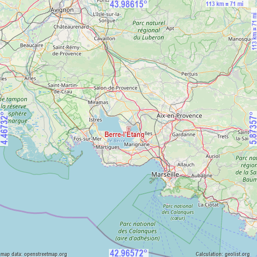
Berre-l'Étang GPS coordinates[2]
43° 28' 41.124" North, 5° 10' 13.584" East
| Map corner | latitude | longitude |
|---|---|---|
| Upper-left | 43.98615°, | 4.46732° |
| Center: | 43.47809°, | 5.17044° |
| Lower-right: | 42.96572°, | 5.87357° |
| Map W x H: | 113.5×113.5 km | = 70.5×70.5mi |
| max Lat: | 51.07786° ⇑93.3% North |
| Berre-l'Étang: | 43.47809° |
| min Lat: | ⇓6.7% South 41.3874° |
| min Long | Berre-l'Étang | max Long |
| -5.08615° | 5.17044° | 9.52242° |
| W 79.4%⇐ | ⇒20.6% E |
Elevation
Elevation of Berre-l'Étang is 3 m = 10 ft, and this is 190.7 m = 626 ft below average elevation for this country.
| Max E: |
2333 m = 7654 ft | 99.8% |
| Avg. | 193.7 m = 635 ft | |
| Berre-l'Étang | 3 m = 10 ft | |
Min E: |
-1 m = -3 ft | 0.2% |
See also: France elevation on elevation.city.
Geographical zone
Berre-l'Étang is located in North temperate zone (between Tropic of Cancer and the Arctic Circle). Distance of this Northern Tropic circle is 2228.4 km =1384.7 mi to South.| Distance of | km | miles | from Berre-l'Étang |
|---|---|---|---|
| North Pole | 5172.8 | 3214.2 | to North |
| Arctic Circle | 2566.9 | 1595 | to North |
| Tropic Cancer | 2228.4 | 1384.7 | to South |
| Equator | 4834.3 | 3003.9 | to South |


Nearby cities:
15 places around Berre-l'Étang: (largest is in red/bold)
• Châteauneuf-les-Martigues
10.5 km =6.5 mi,  182°
182°
• Cornillon-Confoux
12.3 km =7.6 mi,  319°
319°
• Coudoux
10.9 km =6.8 mi,  35°
35°
• Gignac-la-Nerthe
10.8 km =6.7 mi,  150°
150°
• La Fare-les-Oliviers
8.3 km =5.2 mi,  13°
13°
• Lançon-Provence
13.2 km =8.2 mi,  344°
344°
• Les Pennes-Mirabeau
13.5 km =8.4 mi,  124°
124°
• Marignane
7.6 km =4.7 mi, 152°
• Martigues
12.2 km =7.6 mi,  229°
229°
• Rognac
5.2 km =3.2 mi,  78°
78°
• Saint-Mitre-les-Remparts
12.9 km =8 mi,  258°
258°
• Saint-Victoret
8.3 km =5.2 mi,  141°
141°
• Velaux
8.9 km =5.5 mi,  51°
51°
• Ventabren
12.1 km =7.5 mi,  56°
56°
• Vitrolles
6.6 km =4.1 mi,  107°
107°
Sources, notices
• [Note1] Compared only with cities in France existing in our database
• [Src1] Map data: © OpenStreetMap contributors (CC-BY-SA)
• [Src2] Other city data from geonames.org with taken over terms of usage.
• [Src3] Geographical zone / Annual Mean Temperature by Robert A. Rohde @ Wikipedia
