Condé-Folie geodata
Condé-Folie (Hauts-de-France) is a populated place; located in France in Europe/Paris (GMT+2) time zone. With population of 828 people, there are 10310 cities with bigger population in this country. Compared to other cities in France, 93.6% of cities are located further ↓South; 57% of cities are located further →East and 95.4% of cities have higher elevation than Condé-Folie. Note1
Administrative division(s):
- Level 1: Hauts-de-France
- Level 2: Somme
- Level 3: Abbeville
- Level 4: Condé-Folie


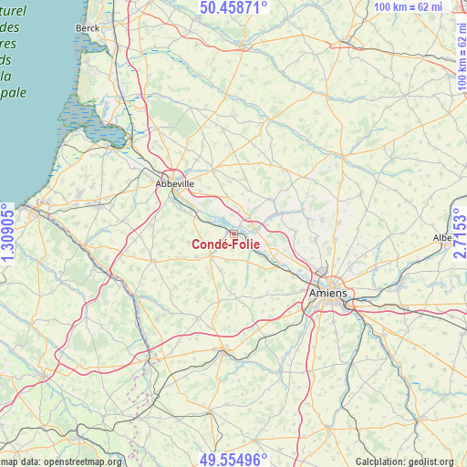
Condé-Folie GPS coordinates[2]
50° 0' 32.256" North, 2° 0' 43.812" East
| Map corner | latitude | longitude |
|---|---|---|
| Upper-left | 50.45871°, | 1.30905° |
| Center: | 50.00896°, | 2.01217° |
| Lower-right: | 49.55496°, | 2.7153° |
| Map W x H: | 100.5×100.5 km | = 62.4×62.4mi |
| max Lat: | 51.07786° ⇑6.4% North |
| Condé-Folie: | 50.00896° |
| min Lat: | ⇓93.6% South 41.3874° |
| min Long | Condé-Folie | max Long |
| -5.08615° | 2.01217° | 9.52242° |
| W 43%⇐ | ⇒57% E |
Elevation
Elevation of Condé-Folie is 16 m = 52 ft, and this is 177.7 m = 583 ft below average elevation for this country.
| Max E: |
2333 m = 7654 ft | 95.4% |
| Avg. | 193.7 m = 635 ft | |
| Condé-Folie | 16 m = 52 ft | |
Min E: |
-1 m = -3 ft | 4.6% |
See also: France elevation on elevation.city.
Geographical zone
Condé-Folie is located in North temperate zone (between Tropic of Cancer and the Arctic Circle). Distance of this North polar circle is 1840.7 km =1143.8 mi to North.| Distance of | km | miles | from Condé-Folie |
|---|---|---|---|
| North Pole | 4446.6 | 2763 | to North |
| Arctic Circle | 1840.7 | 1143.8 | to North |
| Tropic Cancer | 2954.6 | 1835.9 | to South |
| Equator | 5560.5 | 3455.1 | to South |


Nearby cities:
15 places around Condé-Folie: (largest is in red/bold)
• Ailly-le-Haut-Clocher
7.9 km =4.9 mi,  350°
350°
• Airaines
6.7 km =4.2 mi,  227°
227°
• Allery
9.6 km =6 mi,  238°
238°
• Berteaucourt-les-Dames
11.2 km =7 mi,  67°
67°
• Domart-en-Ponthieu
10.9 km =6.8 mi,  48°
48°
• Flixecourt
5 km =3.1 mi,  82°
82°
• Hallencourt
9.9 km =6.2 mi,  259°
259°
• Hangest-sur-Somme
4.9 km =3 mi,  129°
129°
• La Chaussée-Tirancourt
11.6 km =7.2 mi,  121°
121°
• Long
4.2 km =2.6 mi,  326°
326°
• Longpré-les-Corps-Saints
1.4 km =0.9 mi,  285°
285°
• Picquigny
11.9 km =7.4 mi, 127°
• Pont-Remy
8.2 km =5.1 mi,  303°
303°
• Saint-Léger-lès-Domart
10.4 km =6.5 mi,  62°
62°
• Saint-Ouen
8.4 km =5.2 mi, 67°
Sources, notices
• [Note1] Compared only with cities in France existing in our database
• [Src1] Map data: © OpenStreetMap contributors (CC-BY-SA)
• [Src2] Other city data from geonames.org with taken over terms of usage.
• [Src3] Geographical zone / Annual Mean Temperature by Robert A. Rohde @ Wikipedia
