Berteaucourt-les-Dames geodata
Berteaucourt-les-Dames (Hauts-de-France) is a populated place; located in France in Europe/Paris (GMT+2) time zone. With population of 1,123 people, there are 7991 cities with bigger population in this country. Compared to other cities in France, 93.9% of cities are located further ↓South; 55.1% of cities are located further →East and 84.9% of cities have higher elevation than Berteaucourt-les-Dames. Note1
Administrative division(s):
- Level 1: Hauts-de-France
- Level 2: Somme
- Level 3: Amiens
- Level 4: Berteaucourt-les-Dames
Current local time in Berteaucourt-les-Dames:
02:18 AM, SaturdayDifference from your time zone: hours


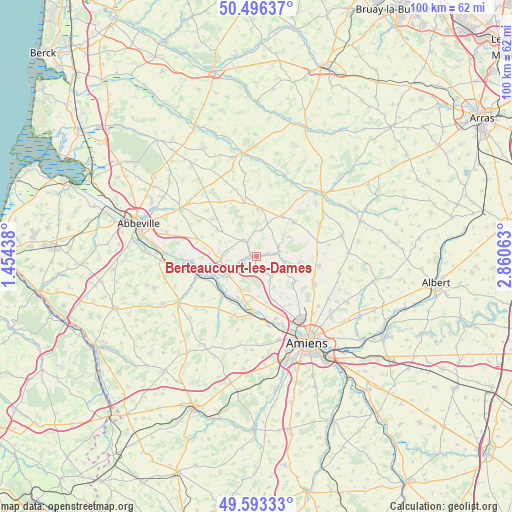
Berteaucourt-les-Dames GPS coordinates[2]
50° 2' 49.092" North, 2° 9' 27" East
| Map corner | latitude | longitude |
|---|---|---|
| Upper-left | 50.49637°, | 1.45438° |
| Center: | 50.04697°, | 2.1575° |
| Lower-right: | 49.59333°, | 2.86063° |
| Map W x H: | 100.4×100.4 km | = 62.4×62.4mi |
| max Lat: | 51.07786° ⇑6.1% North |
| Berteaucourt-les-Dames: | 50.04697° |
| min Lat: | ⇓93.9% South 41.3874° |
| min Long | Berteaucourt-le | max Long |
| -5.08615° | 2.1575° | 9.52242° |
| W 44.9%⇐ | ⇒55.1% E |
Elevation
Elevation of Berteaucourt-les-Dames is 42 m = 138 ft, and this is 151.7 m = 498 ft below average elevation for this country.
| Max E: |
2333 m = 7654 ft | 84.9% |
| Avg. | 193.7 m = 635 ft | |
| Berteaucourt-les-Dames | 42 m = 138 ft | |
Min E: |
-1 m = -3 ft | 15.1% |
See also: France elevation on elevation.city.
Geographical zone
Berteaucourt-les-Dames is located in North temperate zone (between Tropic of Cancer and the Arctic Circle). Distance of this North polar circle is 1836.5 km =1141.1 mi to North.| Distance of | km | miles | from Berteaucourt-les-Dames |
|---|---|---|---|
| North Pole | 4442.4 | 2760.4 | to North |
| Arctic Circle | 1836.5 | 1141.1 | to North |
| Tropic Cancer | 2958.8 | 1838.5 | to South |
| Equator | 5564.7 | 3457.7 | to South |


Nearby cities:
15 places around Berteaucourt-les-Dames: (largest is in red/bold)
• Bernaville
9.5 km =5.9 mi,  2°
2°
• Canaples
4.5 km =2.8 mi,  77°
77°
• Candas
9.9 km =6.2 mi,  47°
47°
• Domart-en-Ponthieu
3.8 km =2.4 mi,  323°
323°
• Fienvillers
9.4 km =5.8 mi,  32°
32°
• Flesselles
8.9 km =5.5 mi,  124°
124°
• Flixecourt
6.5 km =4 mi,  236°
236°
• Hangest-sur-Somme
9.9 km =6.2 mi,  222°
222°
• La Chaussée-Tirancourt
10.4 km =6.5 mi,  183°
183°
• Naours
8.6 km =5.3 mi,  97°
97°
• Pernois
2.2 km =1.4 mi,  72°
72°
• Saint-Léger-lès-Domart
1.3 km =0.8 mi,  295°
295°
• Saint-Ouen
2.8 km =1.7 mi,  249°
249°
• Saint-Vaast-en-Chaussée
9.4 km =5.8 mi,  161°
161°
• Vignacourt
4.8 km =3 mi,  143°
143°
Sources, notices
• [Note1] Compared only with cities in France existing in our database
• [Src1] Map data: © OpenStreetMap contributors (CC-BY-SA)
• [Src2] Other city data from geonames.org with taken over terms of usage.
• [Src3] Geographical zone / Annual Mean Temperature by Robert A. Rohde @ Wikipedia
