Claveisolles geodata
Claveisolles (Auvergne-Rhône-Alpes) is a populated place; located in France in Europe/Paris (GMT+2) time zone. With population of 588 people, there are 13513 cities with bigger population in this country. Compared to other cities in France, 65.1% of cities are located further ↑North; 72.1% of cities are located further ←West and 91.3% of cities have lower elevation than Claveisolles. Note1
Administrative division(s):
- Level 1: Auvergne-Rhône-Alpes
- Level 2: Département du Rhône
- Level 3: Arrondissement de Villefranche-sur-Saône
- Level 4: Claveisolles


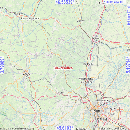
Claveisolles GPS coordinates[2]
46° 6' 0" North, 4° 29' 38.436" East
| Map corner | latitude | longitude |
|---|---|---|
| Upper-left | 46.58539°, | 3.79089° |
| Center: | 46.1°, | 4.49401° |
| Lower-right: | 45.6103°, | 5.19714° |
| Map W x H: | 108.4×108.4 km | = 67.4×67.4mi |
| max Lat: | 51.07786° ⇑65.1% North |
| Claveisolles: | 46.1° |
| min Lat: | ⇓34.9% South 41.3874° |
| min Long | Claveisolles | max Long |
| -5.08615° | 4.49401° | 9.52242° |
| W 72.1%⇐ | ⇒27.9% E |
Elevation
Elevation of Claveisolles is 457 m = 1499 ft, and this is 263.3 m = 864 ft above average elevation for this country.
| Max E: |
2333 m = 7654 ft | 8.7% |
| Claveisolles | 457 m 1499 ft | |
| Avg. | 193.7 m = 635 ft | |
Min E: |
-1 m = -3 ft | 91.3% |
See also: France elevation on elevation.city.
Geographical zone
Claveisolles is located in North temperate zone (between Tropic of Cancer and the Arctic Circle). Distance of this North polar circle is 2275.3 km =1413.8 mi to North.| Distance of | km | miles | from Claveisolles |
|---|---|---|---|
| North Pole | 4881.2 | 3033 | to North |
| Arctic Circle | 2275.3 | 1413.8 | to North |
| Tropic Cancer | 2519.9 | 1565.8 | to South |
| Equator | 5125.8 | 3185 | to South |


Nearby cities:
15 places around Claveisolles: (largest is in red/bold)
• Beaujeu
9.4 km =5.8 mi,  50°
50°
• Chambost-Allières
9.1 km =5.7 mi,  177°
177°
• Grandris
7.1 km =4.4 mi,  191°
191°
• Lamure-sur-Azergues
4.2 km =2.6 mi, 182°
• Lantignié
11.3 km =7 mi,  62°
62°
• Le Perréon
9.2 km =5.7 mi,  116°
116°
• Les Ardillats
9.5 km =5.9 mi,  22°
22°
• Mardore
12.5 km =7.8 mi,  254°
254°
• Odenas
11.8 km =7.3 mi,  96°
96°
• Poule-les-Écharmeaux
6.1 km =3.8 mi,  332°
332°
• Quincié-en-Beaujolais
9.7 km =6 mi,  77°
77°
• Saint-Nizier-d’Azergues
2.6 km =1.6 mi,  237°
237°
• Saint-Étienne-des-Oullières
12.5 km =7.8 mi,  106°
106°
• Saint-Étienne-la-Varenne
10.9 km =6.8 mi, 103°
• Vaux-en-Beaujolais
9 km =5.6 mi, 122°
Sources, notices
• [Note1] Compared only with cities in France existing in our database
• [Src1] Map data: © OpenStreetMap contributors (CC-BY-SA)
• [Src2] Other city data from geonames.org with taken over terms of usage.
• [Src3] Geographical zone / Annual Mean Temperature by Robert A. Rohde @ Wikipedia
