Grandris geodata
Grandris (Auvergne-Rhône-Alpes) is a populated place; located in France in Europe/Paris (GMT+2) time zone. With population of 1,090 people, there are 8193 cities with bigger population in this country. Compared to other cities in France, 65.8% of cities are located further ↑North; 71.9% of cities are located further ←West and 88.6% of cities have lower elevation than Grandris. Note1
Administrative division(s):
- Level 1: Auvergne-Rhône-Alpes
- Level 2: Département du Rhône
- Level 3: Arrondissement de Villefranche-sur-Saône
- Level 4: Grandris


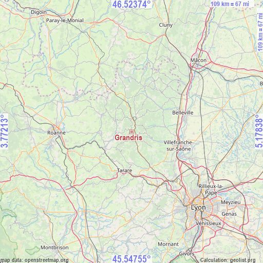
Grandris GPS coordinates[2]
46° 2' 16.08" North, 4° 28' 30.936" East
| Map corner | latitude | longitude |
|---|---|---|
| Upper-left | 46.52374°, | 3.77213° |
| Center: | 46.0378°, | 4.47526° |
| Lower-right: | 45.54755°, | 5.17838° |
| Map W x H: | 108.5×108.5 km | = 67.4×67.4mi |
| max Lat: | 51.07786° ⇑65.8% North |
| Grandris: | 46.0378° |
| min Lat: | ⇓34.2% South 41.3874° |
| min Long | Grandris | max Long |
| -5.08615° | 4.47526° | 9.52242° |
| W 71.9%⇐ | ⇒28.1% E |
Elevation
Elevation of Grandris is 400 m = 1312 ft, and this is 206.3 m = 677 ft above average elevation for this country.
| Max E: |
2333 m = 7654 ft | 11.4% |
| Grandris | 400 m 1312 ft | |
| Avg. | 193.7 m = 635 ft | |
Min E: |
-1 m = -3 ft | 88.6% |
See also: France elevation on elevation.city.
Geographical zone
Grandris is located in North temperate zone (between Tropic of Cancer and the Arctic Circle). Distance of this North polar circle is 2282.3 km =1418.2 mi to North.| Distance of | km | miles | from Grandris |
|---|---|---|---|
| North Pole | 4888.1 | 3037.3 | to North |
| Arctic Circle | 2282.3 | 1418.2 | to North |
| Tropic Cancer | 2513 | 1561.5 | to South |
| Equator | 5118.9 | 3180.7 | to South |


Nearby cities:
15 places around Grandris: (largest is in red/bold)
• Chambost-Allières
2.8 km =1.7 mi,  140°
140°
• Chamelet
6.6 km =4.1 mi,  156°
156°
• Claveisolles
7.1 km =4.4 mi,  11°
11°
• Cublize
7.9 km =4.9 mi,  253°
253°
• Lamure-sur-Azergues
3 km =1.9 mi,  25°
25°
• Le Perréon
10.1 km =6.3 mi,  73°
73°
• Létra
9.2 km =5.7 mi, 155°
• Mardore
11.2 km =7 mi,  288°
288°
• Marnand
11.3 km =7 mi,  268°
268°
• Rivolet
10.4 km =6.5 mi,  109°
109°
• Ronno
9.3 km =5.8 mi,  230°
230°
• Saint-Nizier-d’Azergues
5.6 km =3.5 mi,  352°
352°
• Ternand
11.2 km =7 mi, 158°
• Valsonne
10.8 km =6.7 mi,  199°
199°
• Vaux-en-Beaujolais
9.2 km =5.7 mi,  77°
77°
Sources, notices
• [Note1] Compared only with cities in France existing in our database
• [Src1] Map data: © OpenStreetMap contributors (CC-BY-SA)
• [Src2] Other city data from geonames.org with taken over terms of usage.
• [Src3] Geographical zone / Annual Mean Temperature by Robert A. Rohde @ Wikipedia
