Chambost-Allières geodata
Chambost-Allières (Auvergne-Rhône-Alpes) is a populated place; located in France in Europe/Paris (GMT+2) time zone. With population of 663 people, there are 12328 cities with bigger population in this country. Compared to other cities in France, 66% of cities are located further ↑North; 72.1% of cities are located further ←West and 88.9% of cities have lower elevation than Chambost-Allières. Note1
Administrative division(s):
- Level 1: Auvergne-Rhône-Alpes
- Level 2: Département du Rhône
- Level 3: Arrondissement de Villefranche-sur-Saône
- Level 4: Chambost-Allières


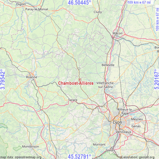
Chambost-Allières GPS coordinates[2]
46° 1' 6.024" North, 4° 29' 54.744" East
| Map corner | latitude | longitude |
|---|---|---|
| Upper-left | 46.50445°, | 3.79542° |
| Center: | 46.01834°, | 4.49854° |
| Lower-right: | 45.52791°, | 5.20167° |
| Map W x H: | 108.6×108.6 km | = 67.5×67.5mi |
| max Lat: | 51.07786° ⇑66% North |
| Chambost-Allières: | 46.01834° |
| min Lat: | ⇓34% South 41.3874° |
| min Long | Chambost-Alliè | max Long |
| -5.08615° | 4.49854° | 9.52242° |
| W 72.1%⇐ | ⇒27.9% E |
Elevation
Elevation of Chambost-Allières is 405 m = 1329 ft, and this is 211.3 m = 693 ft above average elevation for this country.
| Max E: |
2333 m = 7654 ft | 11.1% |
| Chambost-Allières | 405 m 1329 ft | |
| Avg. | 193.7 m = 635 ft | |
Min E: |
-1 m = -3 ft | 88.9% |
See also: France elevation on elevation.city.
Geographical zone
Chambost-Allières is located in North temperate zone (between Tropic of Cancer and the Arctic Circle). Distance of this North polar circle is 2284.4 km =1419.5 mi to North.| Distance of | km | miles | from Chambost-Allières |
|---|---|---|---|
| North Pole | 4890.3 | 3038.7 | to North |
| Arctic Circle | 2284.4 | 1419.5 | to North |
| Tropic Cancer | 2510.8 | 1560.1 | to South |
| Equator | 5116.8 | 3179.4 | to South |


Nearby cities:
15 places around Chambost-Allières: (largest is in red/bold)
• Chamelet
3.9 km =2.4 mi,  167°
167°
• Claveisolles
9.1 km =5.7 mi,  357°
357°
• Cublize
9.4 km =5.8 mi,  269°
269°
• Grandris
2.8 km =1.7 mi,  320°
320°
• Lamure-sur-Azergues
4.9 km =3 mi,  354°
354°
• Le Perréon
9.3 km =5.8 mi,  57°
57°
• Létra
6.5 km =4 mi,  162°
162°
• Oingt
10.1 km =6.3 mi,  139°
139°
• Rivolet
8.1 km =5 mi,  99°
99°
• Ronno
9.7 km =6 mi,  247°
247°
• Saint-Laurent-d’Oingt
9.6 km =6 mi,  148°
148°
• Saint-Nizier-d’Azergues
8.1 km =5 mi,  341°
341°
• Ternand
8.5 km =5.3 mi, 164°
• Valsonne
9.6 km =6 mi,  213°
213°
• Vaux-en-Beaujolais
8.3 km =5.2 mi, 59°
Sources, notices
• [Note1] Compared only with cities in France existing in our database
• [Src1] Map data: © OpenStreetMap contributors (CC-BY-SA)
• [Src2] Other city data from geonames.org with taken over terms of usage.
• [Src3] Geographical zone / Annual Mean Temperature by Robert A. Rohde @ Wikipedia
