Lamure-sur-Azergues geodata
Lamure-sur-Azergues (Auvergne-Rhône-Alpes) is a populated place; located in France in Europe/Paris (GMT+2) time zone. With population of 1,052 people, there are 8449 cities with bigger population in this country. Compared to other cities in France, 65.6% of cities are located further ↑North; 72% of cities are located further ←West and 92.1% of cities have lower elevation than Lamure-sur-Azergues. Note1
Administrative division(s):
- Level 1: Auvergne-Rhône-Alpes
- Level 2: Département du Rhône
- Level 3: Arrondissement de Villefranche-sur-Saône
- Level 4: Lamure-sur-Azergues


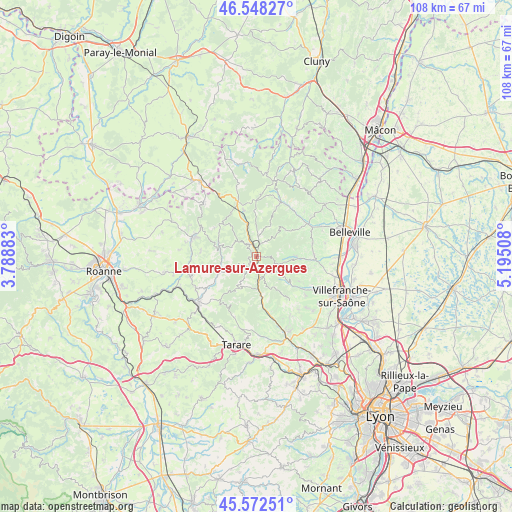
Lamure-sur-Azergues GPS coordinates[2]
46° 3' 45.18" North, 4° 29' 31.02" East
| Map corner | latitude | longitude |
|---|---|---|
| Upper-left | 46.54827°, | 3.78883° |
| Center: | 46.06255°, | 4.49195° |
| Lower-right: | 45.57251°, | 5.19508° |
| Map W x H: | 108.5×108.5 km | = 67.4×67.4mi |
| max Lat: | 51.07786° ⇑65.6% North |
| Lamure-sur-Azergues: | 46.06255° |
| min Lat: | ⇓34.4% South 41.3874° |
| min Long | Lamure-sur-Azer | max Long |
| -5.08615° | 4.49195° | 9.52242° |
| W 72%⇐ | ⇒28% E |
Elevation
Elevation of Lamure-sur-Azergues is 479 m = 1572 ft, and this is 285.3 m = 936 ft above average elevation for this country.
| Max E: |
2333 m = 7654 ft | 7.9% |
| Lamure-sur-Azergues | 479 m 1572 ft | |
| Avg. | 193.7 m = 635 ft | |
Min E: |
-1 m = -3 ft | 92.1% |
See also: France elevation on elevation.city.
Geographical zone
Lamure-sur-Azergues is located in North temperate zone (between Tropic of Cancer and the Arctic Circle). Distance of this North polar circle is 2279.5 km =1416.4 mi to North.| Distance of | km | miles | from Lamure-sur-Azergues |
|---|---|---|---|
| North Pole | 4885.4 | 3035.6 | to North |
| Arctic Circle | 2279.5 | 1416.4 | to North |
| Tropic Cancer | 2515.8 | 1563.2 | to South |
| Equator | 5121.7 | 3182.5 | to South |


Nearby cities:
15 places around Lamure-sur-Azergues: (largest is in red/bold)
• Chambost-Allières
4.9 km =3 mi,  174°
174°
• Chamelet
8.9 km =5.5 mi, 171°
• Claveisolles
4.2 km =2.6 mi,  2°
2°
• Cublize
10.1 km =6.3 mi,  240°
240°
• Grandris
3 km =1.9 mi,  205°
205°
• Le Perréon
8.4 km =5.2 mi,  89°
89°
• Létra
11.4 km =7.1 mi, 167°
• Mardore
11.9 km =7.4 mi,  274°
274°
• Poule-les-Écharmeaux
10 km =6.2 mi,  344°
344°
• Quincié-en-Beaujolais
11.5 km =7.1 mi,  56°
56°
• Rivolet
10.6 km =6.6 mi,  126°
126°
• Ronno
12.1 km =7.5 mi,  224°
224°
• Saint-Nizier-d’Azergues
3.4 km =2.1 mi,  324°
324°
• Saint-Étienne-la-Varenne
10.8 km =6.7 mi,  81°
81°
• Vaux-en-Beaujolais
7.7 km =4.8 mi,  95°
95°
Sources, notices
• [Note1] Compared only with cities in France existing in our database
• [Src1] Map data: © OpenStreetMap contributors (CC-BY-SA)
• [Src2] Other city data from geonames.org with taken over terms of usage.
• [Src3] Geographical zone / Annual Mean Temperature by Robert A. Rohde @ Wikipedia
