Chevry-Cossigny geodata
Chevry-Cossigny (Île-de-France) is a populated place; located in France in Europe/Paris (GMT+2) time zone. With population of 3,575 people, there are 2728 cities with bigger population in this country. Compared to other cities in France, 73.8% of cities are located further ↓South; 52.9% of cities are located further ←West and 59.7% of cities have higher elevation than Chevry-Cossigny. Note1
Administrative division(s):
- Level 1: Île-de-France
- Level 2: Seine-et-Marne
- Level 3: Arrondissement de Torcy
- Level 4: Chevry-Cossigny


Chevry-Cossigny GPS coordinates[2]
48° 43' 28.74" North, 2° 39' 39.816" East
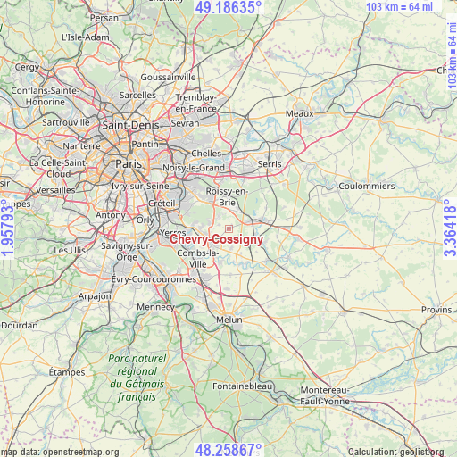
| Map corner | latitude | longitude |
|---|---|---|
| Upper-left | 49.18635°, | 1.95793° |
| Center: | 48.72465°, | 2.66106° |
| Lower-right: | 48.25867°, | 3.36418° |
| Map W x H: | 103.1×103.1 km | = 64.1×64.1mi |
| max Lat: | 51.07786° ⇑26.2% North |
| Chevry-Cossigny: | 48.72465° |
| min Lat: | ⇓73.8% South 41.3874° |
| min Long | Chevry-Cossigny | max Long |
| -5.08615° | 2.66106° | 9.52242° |
| W 52.9%⇐ | ⇒47.1% E |
Elevation
Elevation of Chevry-Cossigny is 103 m = 338 ft, and this is 90.7 m = 298 ft below average elevation for this country.
| Max E: |
2333 m = 7654 ft | 59.7% |
| Avg. | 193.7 m = 635 ft | |
| Chevry-Cossigny | 103 m = 338 ft | |
Min E: |
-1 m = -3 ft | 40.3% |
See also: France elevation on elevation.city.
Geographical zone
Chevry-Cossigny is located in North temperate zone (between Tropic of Cancer and the Arctic Circle). Distance of this North polar circle is 1983.5 km =1232.5 mi to North.| Distance of | km | miles | from Chevry-Cossigny |
|---|---|---|---|
| North Pole | 4589.4 | 2851.7 | to North |
| Arctic Circle | 1983.5 | 1232.5 | to North |
| Tropic Cancer | 2811.8 | 1747.2 | to South |
| Equator | 5417.7 | 3366.4 | to South |


Nearby cities:
15 places around Chevry-Cossigny: (largest is in red/bold)
• Brie-Comte-Robert
5.1 km =3.2 mi,  225°
225°
• Coubert
6.4 km =4 mi,  155°
155°
• Férolles-Attilly
2.4 km =1.5 mi,  289°
289°
• Gretz-Armainvilliers
5.5 km =3.4 mi,  70°
70°
• Grisy-Suisnes
4.4 km =2.7 mi,  173°
173°
• Lésigny
4 km =2.5 mi,  302°
302°
• Ozoir-la-Ferrière
4.7 km =2.9 mi,  6°
6°
• Presles-en-Brie
6 km =3.7 mi,  100°
100°
• Périgny
8.4 km =5.2 mi,  248°
248°
• Roissy-en-Brie
7.5 km =4.7 mi,  352°
352°
• Santeny
6.4 km =4 mi,  272°
272°
• Servon
5.5 km =3.4 mi,  260°
260°
• Soignolles-en-Brie
8.4 km =5.2 mi, 160°
• Solers
8.3 km =5.2 mi,  150°
150°
• Tournan-en-Brie
8.3 km =5.2 mi,  77°
77°
Sources, notices
• [Note1] Compared only with cities in France existing in our database
• [Src1] Map data: © OpenStreetMap contributors (CC-BY-SA)
• [Src2] Other city data from geonames.org with taken over terms of usage.
• [Src3] Geographical zone / Annual Mean Temperature by Robert A. Rohde @ Wikipedia
