Santeny geodata
Santeny (Île-de-France) is a populated place; located in France in Europe/Paris (GMT+2) time zone. With population of 3,266 people, there are 2989 cities with bigger population in this country. Compared to other cities in France, 73.8% of cities are located further ↓South; 51.7% of cities are located further ←West and 63.6% of cities have higher elevation than Santeny. Note1
Administrative division(s):
- Level 1: Île-de-France
- Level 2: Val-de-Marne
- Level 3: Arrondissement de Créteil
- Level 4: Santeny


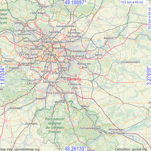
Santeny GPS coordinates[2]
48° 43' 38.28" North, 2° 34' 24.456" East
| Map corner | latitude | longitude |
|---|---|---|
| Upper-left | 49.18897°, | 1.87034° |
| Center: | 48.7273°, | 2.57346° |
| Lower-right: | 48.26135°, | 3.27659° |
| Map W x H: | 103.1×103.1 km | = 64.1×64.1mi |
| max Lat: | 51.07786° ⇑26.2% North |
| Santeny: | 48.7273° |
| min Lat: | ⇓73.8% South 41.3874° |
| min Long | Santeny | max Long |
| -5.08615° | 2.57346° | 9.52242° |
| W 51.7%⇐ | ⇒48.3% E |
Elevation
Elevation of Santeny is 93 m = 305 ft, and this is 100.7 m = 330 ft below average elevation for this country.
| Max E: |
2333 m = 7654 ft | 63.6% |
| Avg. | 193.7 m = 635 ft | |
| Santeny | 93 m = 305 ft | |
Min E: |
-1 m = -3 ft | 36.4% |
See also: France elevation on elevation.city.
Geographical zone
Santeny is located in North temperate zone (between Tropic of Cancer and the Arctic Circle). Distance of this North polar circle is 1983.2 km =1232.3 mi to North.| Distance of | km | miles | from Santeny |
|---|---|---|---|
| North Pole | 4589.1 | 2851.5 | to North |
| Arctic Circle | 1983.2 | 1232.3 | to North |
| Tropic Cancer | 2812 | 1747.3 | to South |
| Equator | 5418 | 3366.6 | to South |


Nearby cities:
15 places around Santeny: (largest is in red/bold)
• Boissy-Saint-Léger
5.3 km =3.3 mi,  300°
300°
• Boussy-Saint-Antoine
5.1 km =3.2 mi,  217°
217°
• Brie-Comte-Robert
4.7 km =2.9 mi,  144°
144°
• Chevry-Cossigny
6.4 km =4 mi,  92°
92°
• Férolles-Attilly
4.2 km =2.6 mi,  83°
83°
• Lésigny
3.6 km =2.2 mi,  59°
59°
• Mandres-les-Roses
3.4 km =2.1 mi,  214°
214°
• Noiseau
5.7 km =3.5 mi,  341°
341°
• Périgny
3.7 km =2.3 mi,  201°
201°
• Servon
1.6 km =1 mi, 139°
• Sucy-en-Brie
5.4 km =3.4 mi,  328°
328°
• Varennes-Jarcy
5.4 km =3.4 mi,  189°
189°
• Villecresnes
2.6 km =1.6 mi,  252°
252°
• Yerres
6 km =3.7 mi,  259°
259°
• Épinay-sous-Sénart
6.2 km =3.9 mi,  227°
227°
Sources, notices
• [Note1] Compared only with cities in France existing in our database
• [Src1] Map data: © OpenStreetMap contributors (CC-BY-SA)
• [Src2] Other city data from geonames.org with taken over terms of usage.
• [Src3] Geographical zone / Annual Mean Temperature by Robert A. Rohde @ Wikipedia
