Férolles-Attilly geodata
Férolles-Attilly (Île-de-France) is a populated place; located in France in Europe/Paris (GMT+2) time zone. With population of 1,129 people, there are 7953 cities with bigger population in this country. Compared to other cities in France, 73.9% of cities are located further ↓South; 52.5% of cities are located further ←West and 63.6% of cities have higher elevation than Férolles-Attilly. Note1
Administrative division(s):
- Level 1: Île-de-France
- Level 2: Seine-et-Marne
- Level 3: Arrondissement de Torcy
- Level 4: Férolles-Attilly


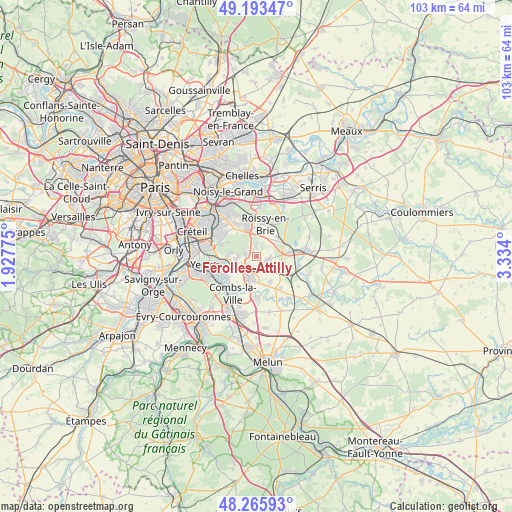
Férolles-Attilly GPS coordinates[2]
48° 43' 54.624" North, 2° 37' 51.168" East
| Map corner | latitude | longitude |
|---|---|---|
| Upper-left | 49.19347°, | 1.92775° |
| Center: | 48.73184°, | 2.63088° |
| Lower-right: | 48.26593°, | 3.334° |
| Map W x H: | 103.1×103.1 km | = 64.1×64.1mi |
| max Lat: | 51.07786° ⇑26.1% North |
| Férolles-Attilly: | 48.73184° |
| min Lat: | ⇓73.9% South 41.3874° |
| min Long | Férolles-Attil | max Long |
| -5.08615° | 2.63088° | 9.52242° |
| W 52.5%⇐ | ⇒47.5% E |
Elevation
Elevation of Férolles-Attilly is 93 m = 305 ft, and this is 100.7 m = 330 ft below average elevation for this country.
| Max E: |
2333 m = 7654 ft | 63.6% |
| Avg. | 193.7 m = 635 ft | |
| Férolles-Attilly | 93 m = 305 ft | |
Min E: |
-1 m = -3 ft | 36.4% |
See also: France elevation on elevation.city.
Geographical zone
Férolles-Attilly is located in North temperate zone (between Tropic of Cancer and the Arctic Circle). Distance of this North polar circle is 1982.7 km =1232 mi to North.| Distance of | km | miles | from Férolles-Attilly |
|---|---|---|---|
| North Pole | 4588.6 | 2851.2 | to North |
| Arctic Circle | 1982.7 | 1232 | to North |
| Tropic Cancer | 2812.6 | 1747.7 | to South |
| Equator | 5418.5 | 3366.9 | to South |


Nearby cities:
15 places around Férolles-Attilly: (largest is in red/bold)
• Brie-Comte-Robert
4.6 km =2.9 mi,  198°
198°
• Chevry-Cossigny
2.4 km =1.5 mi,  109°
109°
• Gretz-Armainvilliers
7.4 km =4.6 mi,  81°
81°
• Grisy-Suisnes
5.8 km =3.6 mi,  152°
152°
• La Queue-en-Brie
7 km =4.3 mi,  328°
328°
• Lésigny
1.8 km =1.1 mi,  318°
318°
• Mandres-les-Roses
7 km =4.3 mi,  241°
241°
• Ozoir-la-Ferrière
4.8 km =3 mi,  35°
35°
• Pontault-Combault
7.6 km =4.7 mi,  346°
346°
• Périgny
6.8 km =4.2 mi,  234°
234°
• Roissy-en-Brie
6.8 km =4.2 mi,  10°
10°
• Santeny
4.2 km =2.6 mi,  263°
263°
• Servon
3.6 km =2.2 mi, 242°
• Varennes-Jarcy
7.8 km =4.8 mi,  220°
220°
• Villecresnes
6.8 km =4.2 mi, 258°
Sources, notices
• [Note1] Compared only with cities in France existing in our database
• [Src1] Map data: © OpenStreetMap contributors (CC-BY-SA)
• [Src2] Other city data from geonames.org with taken over terms of usage.
• [Src3] Geographical zone / Annual Mean Temperature by Robert A. Rohde @ Wikipedia
