Brie-Comte-Robert geodata
Brie-Comte-Robert (Île-de-France) is a populated place; located in France in Europe/Paris (GMT+2) time zone. With population of 15,892 people, there are 604 cities with bigger population in this country. Compared to other cities in France, 73% of cities are located further ↓South; 52.2% of cities are located further ←West and 68.7% of cities have higher elevation than Brie-Comte-Robert. Note1
Administrative division(s):
- Level 1: Île-de-France
- Level 2: Seine-et-Marne
- Level 3: Arrondissement de Torcy
- Level 4: Brie-Comte-Robert


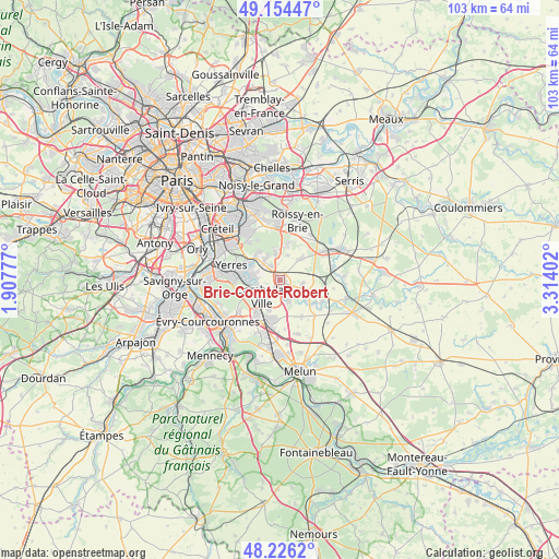
Brie-Comte-Robert GPS coordinates[2]
48° 41' 32.892" North, 2° 36' 39.24" East
| Map corner | latitude | longitude |
|---|---|---|
| Upper-left | 49.15447°, | 1.90777° |
| Center: | 48.69247°, | 2.6109° |
| Lower-right: | 48.2262°, | 3.31402° |
| Map W x H: | 103.2×103.2 km | = 64.1×64.1mi |
| max Lat: | 51.07786° ⇑27% North |
| Brie-Comte-Robert: | 48.69247° |
| min Lat: | ⇓73% South 41.3874° |
| min Long | Brie-Comte-Robe | max Long |
| -5.08615° | 2.6109° | 9.52242° |
| W 52.2%⇐ | ⇒47.8% E |
Elevation
Elevation of Brie-Comte-Robert is 81 m = 266 ft, and this is 112.7 m = 370 ft below average elevation for this country.
| Max E: |
2333 m = 7654 ft | 68.7% |
| Avg. | 193.7 m = 635 ft | |
| Brie-Comte-Robert | 81 m = 266 ft | |
Min E: |
-1 m = -3 ft | 31.3% |
See also: France elevation on elevation.city.
Geographical zone
Brie-Comte-Robert is located in North temperate zone (between Tropic of Cancer and the Arctic Circle). Distance of this North polar circle is 1987.1 km =1234.7 mi to North.| Distance of | km | miles | from Brie-Comte-Robert |
|---|---|---|---|
| North Pole | 4593 | 2854 | to North |
| Arctic Circle | 1987.1 | 1234.7 | to North |
| Tropic Cancer | 2808.2 | 1744.9 | to South |
| Equator | 5414.1 | 3364.2 | to South |


Nearby cities:
15 places around Brie-Comte-Robert: (largest is in red/bold)
• Boussy-Saint-Antoine
5.9 km =3.7 mi,  268°
268°
• Chevry-Cossigny
5.1 km =3.2 mi,  45°
45°
• Combs-la-Ville
4.3 km =2.7 mi,  224°
224°
• Coubert
6.7 km =4.2 mi,  109°
109°
• Férolles-Attilly
4.6 km =2.9 mi,  18°
18°
• Grisy-Suisnes
4.3 km =2.7 mi,  100°
100°
• Lésigny
5.7 km =3.5 mi,  3°
3°
• Mandres-les-Roses
4.8 km =3 mi,  282°
282°
• Périgny
4.1 km =2.5 mi, 276°
• Quincy-sous-Sénart
6 km =3.7 mi,  248°
248°
• Santeny
4.7 km =2.9 mi,  324°
324°
• Servon
3.2 km =2 mi,  327°
327°
• Varennes-Jarcy
3.9 km =2.4 mi, 247°
• Villecresnes
6.1 km =3.8 mi,  300°
300°
• Épinay-sous-Sénart
7.3 km =4.5 mi, 267°
Sources, notices
• [Note1] Compared only with cities in France existing in our database
• [Src1] Map data: © OpenStreetMap contributors (CC-BY-SA)
• [Src2] Other city data from geonames.org with taken over terms of usage.
• [Src3] Geographical zone / Annual Mean Temperature by Robert A. Rohde @ Wikipedia
