Presles-en-Brie geodata
Presles-en-Brie (Île-de-France) is a populated place; located in France in Europe/Paris (GMT+2) time zone. With population of 1,899 people, there are 5035 cities with bigger population in this country. Compared to other cities in France, 73.6% of cities are located further ↓South; 54.1% of cities are located further ←West and 62.4% of cities have higher elevation than Presles-en-Brie. Note1
Administrative division(s):
- Level 1: Île-de-France
- Level 2: Seine-et-Marne
- Level 3: Arrondissement de Provins
- Level 4: Presles-en-Brie


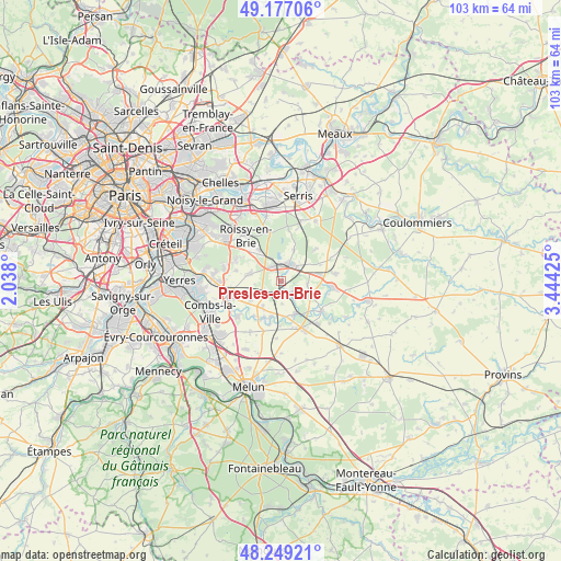
Presles-en-Brie GPS coordinates[2]
48° 42' 54.972" North, 2° 44' 28.032" East
| Map corner | latitude | longitude |
|---|---|---|
| Upper-left | 49.17706°, | 2.038° |
| Center: | 48.71527°, | 2.74112° |
| Lower-right: | 48.24921°, | 3.44425° |
| Map W x H: | 103.2×103.2 km | = 64.1×64.1mi |
| max Lat: | 51.07786° ⇑26.4% North |
| Presles-en-Brie: | 48.71527° |
| min Lat: | ⇓73.6% South 41.3874° |
| min Long | Presles-en-Brie | max Long |
| -5.08615° | 2.74112° | 9.52242° |
| W 54.1%⇐ | ⇒45.9% E |
Elevation
Elevation of Presles-en-Brie is 96 m = 315 ft, and this is 97.7 m = 321 ft below average elevation for this country.
| Max E: |
2333 m = 7654 ft | 62.4% |
| Avg. | 193.7 m = 635 ft | |
| Presles-en-Brie | 96 m = 315 ft | |
Min E: |
-1 m = -3 ft | 37.6% |
See also: France elevation on elevation.city.
Geographical zone
Presles-en-Brie is located in North temperate zone (between Tropic of Cancer and the Arctic Circle). Distance of this North polar circle is 1984.5 km =1233.1 mi to North.| Distance of | km | miles | from Presles-en-Brie |
|---|---|---|---|
| North Pole | 4590.4 | 2852.3 | to North |
| Arctic Circle | 1984.5 | 1233.1 | to North |
| Tropic Cancer | 2810.7 | 1746.5 | to South |
| Equator | 5416.6 | 3365.7 | to South |


Nearby cities:
15 places around Presles-en-Brie: (largest is in red/bold)
• Chaumes-en-Brie
8.9 km =5.5 mi,  125°
125°
• Chevry-Cossigny
6 km =3.7 mi,  280°
280°
• Châtres
5.1 km =3.2 mi,  96°
96°
• Coubert
5.8 km =3.6 mi,  213°
213°
• Favières
5.9 km =3.7 mi,  24°
24°
• Férolles-Attilly
8.3 km =5.2 mi, 282°
• Gretz-Armainvilliers
3 km =1.9 mi,  345°
345°
• Grisy-Suisnes
6.3 km =3.9 mi,  238°
238°
• Liverdy-en-Brie
3.1 km =1.9 mi,  123°
123°
• Neufmoutiers-en-Brie
8.9 km =5.5 mi,  48°
48°
• Ozoir-la-Ferrière
7.8 km =4.8 mi,  317°
317°
• Ozouer-le-Voulgis
6.6 km =4.1 mi,  158°
158°
• Soignolles-en-Brie
7.5 km =4.7 mi,  203°
203°
• Solers
6.5 km =4 mi, 196°
• Tournan-en-Brie
3.7 km =2.3 mi,  37°
37°
Sources, notices
• [Note1] Compared only with cities in France existing in our database
• [Src1] Map data: © OpenStreetMap contributors (CC-BY-SA)
• [Src2] Other city data from geonames.org with taken over terms of usage.
• [Src3] Geographical zone / Annual Mean Temperature by Robert A. Rohde @ Wikipedia
