Chauray geodata
Chauray (Nouvelle-Aquitaine) is a populated place; located in France in Europe/Paris (GMT+2) time zone. With population of 4,858 people, there are 2044 cities with bigger population in this country. Compared to other cities in France, 61.6% of cities are located further ↑North; 81.8% of cities are located further →East and 75.4% of cities have higher elevation than Chauray. Note1
Administrative division(s):
- Level 1: Nouvelle-Aquitaine
- Level 2: Département des Deux-Sèvres
- Level 3: Arrondissement de Niort
- Level 4: Chauray


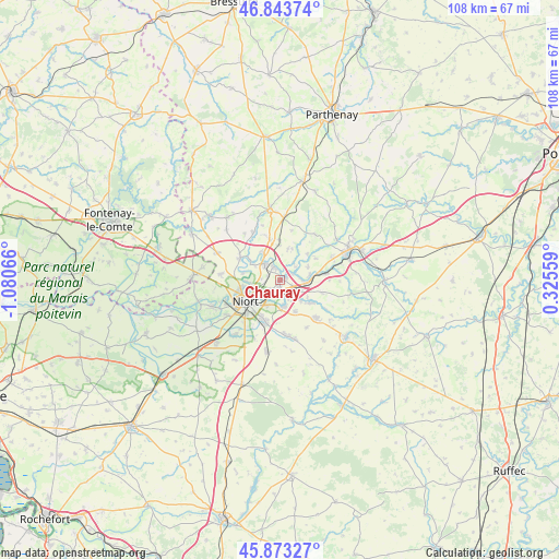
Chauray GPS coordinates[2]
46° 21' 38.376" North, 0° 22' 39.108" West
| Map corner | latitude | longitude |
|---|---|---|
| Upper-left | 46.84374°, | -1.08066° |
| Center: | 46.36066°, | -0.37753° |
| Lower-right: | 45.87327°, | 0.32559° |
| Map W x H: | 107.9×107.9 km | = 67×67mi |
| max Lat: | 51.07786° ⇑61.6% North |
| Chauray: | 46.36066° |
| min Lat: | ⇓38.4% South 41.3874° |
| min Long | Chauray | max Long |
| -5.08615° | -0.37753° | 9.52242° |
| W 18.2%⇐ | ⇒81.8% E |
Elevation
Elevation of Chauray is 66 m = 217 ft, and this is 127.7 m = 419 ft below average elevation for this country.
| Max E: |
2333 m = 7654 ft | 75.4% |
| Avg. | 193.7 m = 635 ft | |
| Chauray | 66 m = 217 ft | |
Min E: |
-1 m = -3 ft | 24.6% |
See also: France elevation on elevation.city.
Geographical zone
Chauray is located in North temperate zone (between Tropic of Cancer and the Arctic Circle). Distance of this North polar circle is 2246.4 km =1395.8 mi to North.| Distance of | km | miles | from Chauray |
|---|---|---|---|
| North Pole | 4852.2 | 3015 | to North |
| Arctic Circle | 2246.4 | 1395.8 | to North |
| Tropic Cancer | 2548.9 | 1583.8 | to South |
| Equator | 5154.8 | 3203 | to South |


Nearby cities:
15 places around Chauray: (largest is in red/bold)
• Aiffres
8.5 km =5.3 mi,  199°
199°
• Azay-le-Brûlé
11 km =6.8 mi,  65°
65°
• Cherveux
6.3 km =3.9 mi,  14°
14°
• François
2.7 km =1.7 mi,  64°
64°
• Germond-Rouvre
10.4 km =6.5 mi,  343°
343°
• La Crèche
6 km =3.7 mi,  83°
83°
• Mougon
10.1 km =6.3 mi,  136°
136°
• Niort
7.5 km =4.7 mi,  236°
236°
• Saint-Gelais
2.6 km =1.6 mi, 339°
• Saint-Maxire
8.9 km =5.5 mi,  299°
299°
• Sainte-Néomaye
9.2 km =5.7 mi, 81°
• Sainte-Ouenne
10.6 km =6.6 mi,  330°
330°
• Sciecq
7.3 km =4.5 mi,  280°
280°
• Vouillé
5.1 km =3.2 mi,  171°
171°
• Échiré
4.4 km =2.7 mi,  317°
317°
Sources, notices
• [Note1] Compared only with cities in France existing in our database
• [Src1] Map data: © OpenStreetMap contributors (CC-BY-SA)
• [Src2] Other city data from geonames.org with taken over terms of usage.
• [Src3] Geographical zone / Annual Mean Temperature by Robert A. Rohde @ Wikipedia
