Chasseneuil-sur-Bonnieure geodata
Chasseneuil-sur-Bonnieure (Nouvelle-Aquitaine) is a populated place; located in France in Europe/Paris (GMT+2) time zone. With population of 3,156 people, there are 3084 cities with bigger population in this country. Compared to other cities in France, 69% of cities are located further ↑North; 73.9% of cities are located further →East and 55.6% of cities have higher elevation than Chasseneuil-sur-Bonnieure. Note1
Administrative division(s):
- Level 1: Nouvelle-Aquitaine
- Level 2: Charente
- Level 3: Arrondissement de Confolens
- Level 4: Chasseneuil-sur-Bonnieure
Current local time in Chasseneuil-sur-Bonnieure:
02:36 PM, SaturdayDifference from your time zone: hours


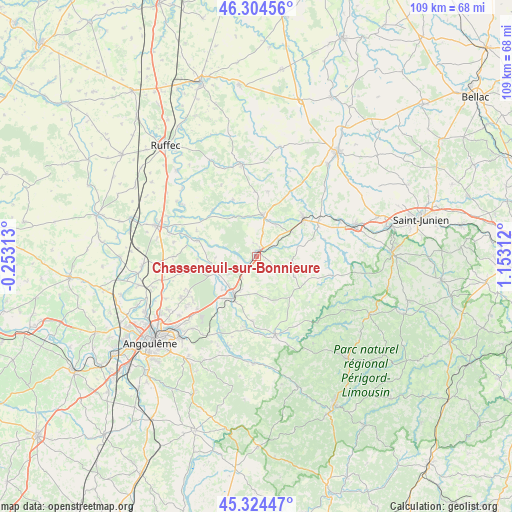
Chasseneuil-sur-Bonnieure GPS coordinates[2]
45° 49' 0.012" North, 0° 27' 0" East
| Map corner | latitude | longitude |
|---|---|---|
| Upper-left | 46.30456°, | -0.25313° |
| Center: | 45.81667°, | 0.45° |
| Lower-right: | 45.32447°, | 1.15312° |
| Map W x H: | 109×109 km | = 67.7×67.7mi |
| max Lat: | 51.07786° ⇑69% North |
| Chasseneuil-sur-Bonnieure: | 45.81667° |
| min Lat: | ⇓31% South 41.3874° |
| min Long | Chasseneuil-sur | max Long |
| -5.08615° | 0.45° | 9.52242° |
| W 26.1%⇐ | ⇒73.9% E |
Elevation
Elevation of Chasseneuil-sur-Bonnieure is 115 m = 377 ft, and this is 78.7 m = 258 ft below average elevation for this country.
| Max E: |
2333 m = 7654 ft | 55.6% |
| Avg. | 193.7 m = 635 ft | |
| Chasseneuil-sur-Bonnieure | 115 m = 377 ft | |
Min E: |
-1 m = -3 ft | 44.4% |
See also: France elevation on elevation.city.
Geographical zone
Chasseneuil-sur-Bonnieure is located in North temperate zone (between Tropic of Cancer and the Arctic Circle). Distance of this North polar circle is 2306.8 km =1433.4 mi to North.| Distance of | km | miles | from Chasseneuil-sur-Bonnieure |
|---|---|---|---|
| North Pole | 4912.7 | 3052.6 | to North |
| Arctic Circle | 2306.8 | 1433.4 | to North |
| Tropic Cancer | 2488.4 | 1546.2 | to South |
| Equator | 5094.3 | 3165.5 | to South |


Nearby cities:
15 places around Chasseneuil-sur-Bonnieure: (largest is in red/bold)
• Agris
10 km =6.2 mi,  242°
242°
• Genouillac
10.2 km =6.3 mi,  66°
66°
• La Rochefoucauld
9.8 km =6.1 mi,  210°
210°
• La Rochette
10.7 km =6.6 mi,  260°
260°
• Marillac-le-Franc
9.4 km =5.8 mi,  187°
187°
• Montembœuf
9.1 km =5.7 mi,  118°
118°
• Nieuil
7.9 km =4.9 mi,  29°
29°
• Rivières
9.9 km =6.2 mi,  224°
224°
• Roumazières-Loubert
12.8 km =8 mi,  52°
52°
• Saint-Angeau
13.1 km =8.1 mi,  285°
285°
• Saint-Claud
8.8 km =5.5 mi,  7°
7°
• Saint-Projet-Saint-Constant
13.1 km =8.1 mi, 221°
• Saint-Sornin
13.8 km =8.6 mi,  184°
184°
• Taponnat-Fleurignac
5.3 km =3.3 mi, 216°
• Vitrac-Saint-Vincent
4.1 km =2.5 mi, 124°
Sources, notices
• [Note1] Compared only with cities in France existing in our database
• [Src1] Map data: © OpenStreetMap contributors (CC-BY-SA)
• [Src2] Other city data from geonames.org with taken over terms of usage.
• [Src3] Geographical zone / Annual Mean Temperature by Robert A. Rohde @ Wikipedia
