Saint-Claud geodata
Saint-Claud (Nouvelle-Aquitaine) is a populated place; located in France in Europe/Paris (GMT+2) time zone. With population of 1,104 people, there are 8107 cities with bigger population in this country. Compared to other cities in France, 67.7% of cities are located further ↑North; 73.7% of cities are located further →East and 56.6% of cities have lower elevation than Saint-Claud. Note1
Administrative division(s):
- Level 1: Nouvelle-Aquitaine
- Level 2: Charente
- Level 3: Arrondissement de Confolens
- Level 4: Saint-Claud


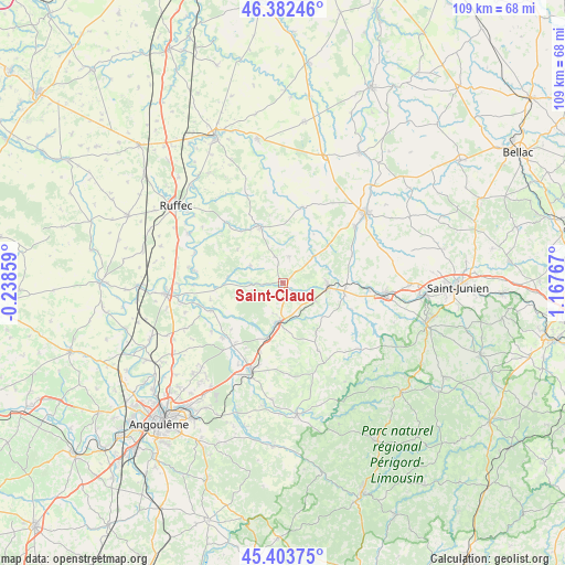
Saint-Claud GPS coordinates[2]
45° 53' 42.936" North, 0° 27' 52.344" East
| Map corner | latitude | longitude |
|---|---|---|
| Upper-left | 46.38246°, | -0.23859° |
| Center: | 45.89526°, | 0.46454° |
| Lower-right: | 45.40375°, | 1.16767° |
| Map W x H: | 108.8×108.8 km | = 67.6×67.6mi |
| max Lat: | 51.07786° ⇑67.7% North |
| Saint-Claud: | 45.89526° |
| min Lat: | ⇓32.3% South 41.3874° |
| min Long | Saint-Claud | max Long |
| -5.08615° | 0.46454° | 9.52242° |
| W 26.3%⇐ | ⇒73.7% E |
Elevation
Elevation of Saint-Claud is 156 m = 512 ft, and this is 37.7 m = 124 ft below average elevation for this country.
| Max E: |
2333 m = 7654 ft | 43.4% |
| Avg. | 193.7 m = 635 ft | |
| Saint-Claud | 156 m = 512 ft | |
Min E: |
-1 m = -3 ft | 56.6% |
See also: France elevation on elevation.city.
Geographical zone
Saint-Claud is located in North temperate zone (between Tropic of Cancer and the Arctic Circle). Distance of this North polar circle is 2298.1 km =1428 mi to North.| Distance of | km | miles | from Saint-Claud |
|---|---|---|---|
| North Pole | 4904 | 3047.2 | to North |
| Arctic Circle | 2298.1 | 1428 | to North |
| Tropic Cancer | 2497.2 | 1551.7 | to South |
| Equator | 5103.1 | 3170.9 | to South |


Nearby cities:
15 places around Saint-Claud: (largest is in red/bold)
• Alloue
15.9 km =9.9 mi,  14°
14°
• Champagne-Mouton
11.4 km =7.1 mi,  338°
338°
• Chasseneuil-sur-Bonnieure
8.8 km =5.5 mi,  187°
187°
• Chirac
14.9 km =9.3 mi,  82°
82°
• Genouillac
9.5 km =5.9 mi,  119°
119°
• La Rochette
15.7 km =9.8 mi,  227°
227°
• Loubert
9.6 km =6 mi, 77°
• Manot
14.4 km =8.9 mi,  68°
68°
• Montembœuf
14.8 km =9.2 mi,  152°
152°
• Nieuil
3.4 km =2.1 mi, 123°
• Roumazières-Loubert
9.1 km =5.7 mi,  95°
95°
• Saint-Angeau
14.7 km =9.1 mi,  249°
249°
• Saint-Laurent-de-Céris
5.3 km =3.3 mi, 13°
• Taponnat-Fleurignac
13.7 km =8.5 mi,  198°
198°
• Vitrac-Saint-Vincent
11.3 km =7 mi,  168°
168°
Sources, notices
• [Note1] Compared only with cities in France existing in our database
• [Src1] Map data: © OpenStreetMap contributors (CC-BY-SA)
• [Src2] Other city data from geonames.org with taken over terms of usage.
• [Src3] Geographical zone / Annual Mean Temperature by Robert A. Rohde @ Wikipedia
