Genouillac geodata
Genouillac (Nouvelle-Aquitaine) is a populated place; located in France in Europe/Paris (GMT+2) time zone. With population of 567 people, there are 13878 cities with bigger population in this country. Compared to other cities in France, 68.4% of cities are located further ↑North; 72.7% of cities are located further →East and 66.1% of cities have lower elevation than Genouillac. Note1
Administrative division(s):
- Level 1: Nouvelle-Aquitaine
- Level 2: Charente
- Level 3: Arrondissement de Confolens
- Level 4: Terres-de-Haute-Charente


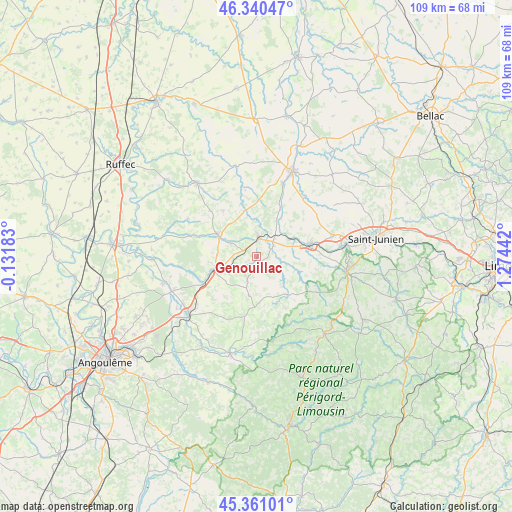
Genouillac GPS coordinates[2]
45° 51' 10.44" North, 0° 34' 16.644" East
| Map corner | latitude | longitude |
|---|---|---|
| Upper-left | 46.34047°, | -0.13183° |
| Center: | 45.8529°, | 0.57129° |
| Lower-right: | 45.36101°, | 1.27442° |
| Map W x H: | 108.9×108.9 km | = 67.7×67.7mi |
| max Lat: | 51.07786° ⇑68.4% North |
| Genouillac: | 45.8529° |
| min Lat: | ⇓31.6% South 41.3874° |
| min Long | Genouillac | max Long |
| -5.08615° | 0.57129° | 9.52242° |
| W 27.3%⇐ | ⇒72.7% E |
Elevation
Elevation of Genouillac is 199 m = 653 ft, and this is 5.3 m = 17 ft above average elevation for this country.
| Max E: |
2333 m = 7654 ft | 33.9% |
| Genouillac | 199 m 653 ft | |
| Avg. | 193.7 m = 635 ft | |
Min E: |
-1 m = -3 ft | 66.1% |
See also: France elevation on elevation.city.
Geographical zone
Genouillac is located in North temperate zone (between Tropic of Cancer and the Arctic Circle). Distance of this North polar circle is 2302.8 km =1430.9 mi to North.| Distance of | km | miles | from Genouillac |
|---|---|---|---|
| North Pole | 4908.7 | 3050.1 | to North |
| Arctic Circle | 2302.8 | 1430.9 | to North |
| Tropic Cancer | 2492.4 | 1548.7 | to South |
| Equator | 5098.4 | 3168 | to South |


Nearby cities:
15 places around Genouillac: (largest is in red/bold)
• Chabanais
11.6 km =7.2 mi,  78°
78°
• Chasseneuil-sur-Bonnieure
10.2 km =6.3 mi,  246°
246°
• Chassenon
15 km =9.3 mi,  90°
90°
• Chirac
9.4 km =5.8 mi,  43°
43°
• Exideuil
8.7 km =5.4 mi,  64°
64°
• Loubert
6.9 km =4.3 mi,  9°
9°
• Manot
11.2 km =7 mi,  27°
27°
• Montembœuf
8.5 km =5.3 mi,  189°
189°
• Nieuil
6.1 km =3.8 mi,  297°
297°
• Roumazières-Loubert
3.9 km =2.4 mi, 11°
• Saint-Claud
9.5 km =5.9 mi, 299°
• Saint-Laurent-de-Céris
12.1 km =7.5 mi,  324°
324°
• Saint-Maurice-des-Lions
16 km =9.9 mi, 39°
• Taponnat-Fleurignac
15 km =9.3 mi,  236°
236°
• Vitrac-Saint-Vincent
8.7 km =5.4 mi,  223°
223°
Sources, notices
• [Note1] Compared only with cities in France existing in our database
• [Src1] Map data: © OpenStreetMap contributors (CC-BY-SA)
• [Src2] Other city data from geonames.org with taken over terms of usage.
• [Src3] Geographical zone / Annual Mean Temperature by Robert A. Rohde @ Wikipedia
