Charsonville geodata
Charsonville (Centre) is a populated place; located in France in Europe/Paris (GMT+2) time zone. With population of 612 people, there are 13126 cities with bigger population in this country. Compared to other cities in France, 58% of cities are located further ↓South; 62% of cities are located further →East and 53.1% of cities have higher elevation than Charsonville. Note1
Administrative division(s):
- Level 1: Centre
- Level 2: Loiret
- Level 3: Arrondissement d’Orléans
- Level 4: Charsonville


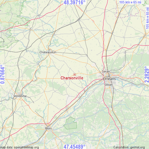
Charsonville GPS coordinates[2]
47° 55' 41.412" North, 1° 34' 47.172" East
| Map corner | latitude | longitude |
|---|---|---|
| Upper-left | 48.39716°, | 0.87664° |
| Center: | 47.92817°, | 1.57977° |
| Lower-right: | 47.45489°, | 2.2829° |
| Map W x H: | 104.8×104.8 km | = 65.1×65.1mi |
| max Lat: | 51.07786° ⇑42% North |
| Charsonville: | 47.92817° |
| min Lat: | ⇓58% South 41.3874° |
| min Long | Charsonville | max Long |
| -5.08615° | 1.57977° | 9.52242° |
| W 38%⇐ | ⇒62% E |
Elevation
Elevation of Charsonville is 122 m = 400 ft, and this is 71.7 m = 235 ft below average elevation for this country.
| Max E: |
2333 m = 7654 ft | 53.1% |
| Avg. | 193.7 m = 635 ft | |
| Charsonville | 122 m = 400 ft | |
Min E: |
-1 m = -3 ft | 46.9% |
See also: France elevation on elevation.city.
Geographical zone
Charsonville is located in North temperate zone (between Tropic of Cancer and the Arctic Circle). Distance of this North polar circle is 2072.1 km =1287.5 mi to North.| Distance of | km | miles | from Charsonville |
|---|---|---|---|
| North Pole | 4677.9 | 2906.7 | to North |
| Arctic Circle | 2072.1 | 1287.5 | to North |
| Tropic Cancer | 2723.2 | 1692.1 | to South |
| Equator | 5329.1 | 3311.3 | to South |


Nearby cities:
15 places around Charsonville: (largest is in red/bold)
• Baccon
5.5 km =3.4 mi,  138°
138°
• Baule
14.8 km =9.2 mi,  152°
152°
• Binas
9.2 km =5.7 mi,  253°
253°
• Chaingy
15.1 km =9.4 mi,  109°
109°
• Coulmiers
6.3 km =3.9 mi,  86°
86°
• Cravant
11.1 km =6.9 mi,  183°
183°
• Huisseau-sur-Mauves
10 km =6.2 mi, 112°
• Le Bardon
10.7 km =6.6 mi, 149°
• Messas
14.1 km =8.8 mi,  162°
162°
• Meung-sur-Loire
13.8 km =8.6 mi, 141°
• Ouzouer-le-Marché
4.5 km =2.8 mi,  243°
243°
• Saint-Ay
14.9 km =9.3 mi,  121°
121°
• Saint-Péravy-la-Colombe
12 km =7.5 mi,  49°
49°
• Villorceau
14.2 km =8.8 mi,  174°
174°
• Épieds-en-Beauce
3.8 km =2.4 mi, 48°
Sources, notices
• [Note1] Compared only with cities in France existing in our database
• [Src1] Map data: © OpenStreetMap contributors (CC-BY-SA)
• [Src2] Other city data from geonames.org with taken over terms of usage.
• [Src3] Geographical zone / Annual Mean Temperature by Robert A. Rohde @ Wikipedia
