Baccon geodata
Baccon (Centre) is a populated place; located in France in Europe/Paris (GMT+2) time zone. With population of 633 people, there are 12771 cities with bigger population in this country. Compared to other cities in France, 57.4% of cities are located further ↓South; 61.3% of cities are located further →East and 53.3% of cities have higher elevation than Baccon. Note1
Administrative division(s):
- Level 1: Centre
- Level 2: Loiret
- Level 3: Arrondissement d’Orléans
- Level 4: Baccon


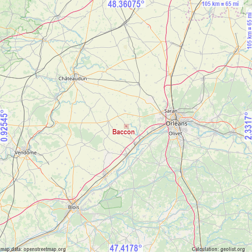
Baccon GPS coordinates[2]
47° 53' 29.112" North, 1° 37' 42.888" East
| Map corner | latitude | longitude |
|---|---|---|
| Upper-left | 48.36075°, | 0.92545° |
| Center: | 47.89142°, | 1.62858° |
| Lower-right: | 47.4178°, | 2.3317° |
| Map W x H: | 104.8×104.8 km | = 65.1×65.1mi |
| max Lat: | 51.07786° ⇑42.6% North |
| Baccon: | 47.89142° |
| min Lat: | ⇓57.4% South 41.3874° |
| min Long | Baccon | max Long |
| -5.08615° | 1.62858° | 9.52242° |
| W 38.7%⇐ | ⇒61.3% E |
Elevation
Elevation of Baccon is 121 m = 397 ft, and this is 72.7 m = 239 ft below average elevation for this country.
| Max E: |
2333 m = 7654 ft | 53.3% |
| Avg. | 193.7 m = 635 ft | |
| Baccon | 121 m = 397 ft | |
Min E: |
-1 m = -3 ft | 46.7% |
See also: France elevation on elevation.city.
Geographical zone
Baccon is located in North temperate zone (between Tropic of Cancer and the Arctic Circle). Distance of this North polar circle is 2076.1 km =1290 mi to North.| Distance of | km | miles | from Baccon |
|---|---|---|---|
| North Pole | 4682 | 2909.3 | to North |
| Arctic Circle | 2076.1 | 1290 | to North |
| Tropic Cancer | 2719.1 | 1689.6 | to South |
| Equator | 5325 | 3308.8 | to South |


Nearby cities:
15 places around Baccon: (largest is in red/bold)
• Baule
9.5 km =5.9 mi,  159°
159°
• Chaingy
10.6 km =6.6 mi,  94°
94°
• Charsonville
5.5 km =3.4 mi,  318°
318°
• Cléry-Saint-André
11.9 km =7.4 mi,  130°
130°
• Coulmiers
5.2 km =3.2 mi,  31°
31°
• Cravant
8.2 km =5.1 mi,  211°
211°
• Huisseau-sur-Mauves
5.5 km =3.4 mi, 87°
• Le Bardon
5.5 km =3.4 mi, 161°
• Mareau-aux-Prés
11.9 km =7.4 mi,  103°
103°
• Messas
9.4 km =5.8 mi,  176°
176°
• Meung-sur-Loire
8.4 km =5.2 mi,  143°
143°
• Ouzouer-le-Marché
7.9 km =4.9 mi,  285°
285°
• Saint-Ay
9.8 km =6.1 mi,  111°
111°
• Villorceau
10.3 km =6.4 mi,  193°
193°
• Épieds-en-Beauce
6.6 km =4.1 mi,  352°
352°
Sources, notices
• [Note1] Compared only with cities in France existing in our database
• [Src1] Map data: © OpenStreetMap contributors (CC-BY-SA)
• [Src2] Other city data from geonames.org with taken over terms of usage.
• [Src3] Geographical zone / Annual Mean Temperature by Robert A. Rohde @ Wikipedia
