Javron-les-Chapelles geodata
Javron-les-Chapelles (Pays de la Loire) is a populated place; located in France in Europe/Paris (GMT+2) time zone. With population of 1,456 people, there are 6345 cities with bigger population in this country. Compared to other cities in France, 66.7% of cities are located further ↓South; 81.3% of cities are located further →East and 62.1% of cities have lower elevation than Javron-les-Chapelles. Note1
Administrative division(s):
- Level 1: Pays de la Loire
- Level 2: Mayenne
- Level 3: Arrondissement de Mayenne
- Level 4: Javron-les-Chapelles


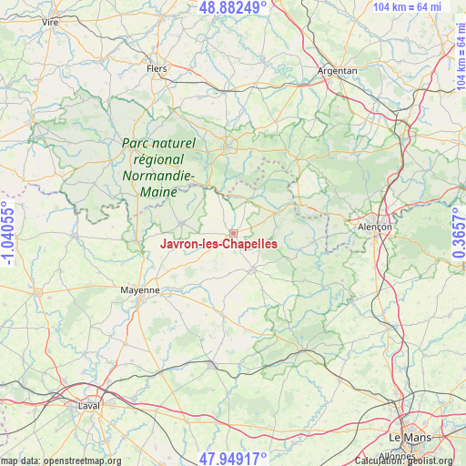
Javron-les-Chapelles GPS coordinates[2]
48° 25' 4.692" North, 0° 20' 14.712" West
| Map corner | latitude | longitude |
|---|---|---|
| Upper-left | 48.88249°, | -1.04055° |
| Center: | 48.41797°, | -0.33742° |
| Lower-right: | 47.94917°, | 0.3657° |
| Map W x H: | 103.8×103.8 km | = 64.5×64.5mi |
| max Lat: | 51.07786° ⇑33.3% North |
| Javron-les-Chapelles: | 48.41797° |
| min Lat: | ⇓66.7% South 41.3874° |
| min Long | Javron-les-Chap | max Long |
| -5.08615° | -0.33742° | 9.52242° |
| W 18.7%⇐ | ⇒81.3% E |
Elevation
Elevation of Javron-les-Chapelles is 180 m = 591 ft, and this is 13.7 m = 45 ft below average elevation for this country.
| Max E: |
2333 m = 7654 ft | 37.9% |
| Avg. | 193.7 m = 635 ft | |
| Javron-les-Chapelles | 180 m = 591 ft | |
Min E: |
-1 m = -3 ft | 62.1% |
See also: France elevation on elevation.city.
Geographical zone
Javron-les-Chapelles is located in North temperate zone (between Tropic of Cancer and the Arctic Circle). Distance of this North polar circle is 2017.6 km =1253.7 mi to North.| Distance of | km | miles | from Javron-les-Chapelles |
|---|---|---|---|
| North Pole | 4623.5 | 2872.9 | to North |
| Arctic Circle | 2017.6 | 1253.7 | to North |
| Tropic Cancer | 2777.7 | 1726 | to South |
| Equator | 5383.6 | 3345.2 | to South |


Nearby cities:
15 places around Javron-les-Chapelles: (largest is in red/bold)
• Averton
12.8 km =8 mi,  138°
138°
• Bagnoles-de-l'Orne
16.5 km =10.3 mi,  340°
340°
• Champgenéteux
14.2 km =8.8 mi,  187°
187°
• Champéon
14.4 km =8.9 mi,  247°
247°
• Courcité
14 km =8.7 mi,  152°
152°
• Couterne
12 km =7.5 mi,  331°
331°
• Gesvres
15.1 km =9.4 mi,  111°
111°
• Lassay-les-Châteaux
12 km =7.5 mi,  280°
280°
• Le Horps
9.4 km =5.8 mi,  256°
256°
• Lignières-Orgères
16.9 km =10.5 mi,  34°
34°
• Magny-le-Désert
16.9 km =10.5 mi,  2°
2°
• Marcillé-la-Ville
17 km =10.6 mi,  222°
222°
• Pré-en-Pail
11.3 km =7 mi,  65°
65°
• Tessé-la-Madeleine
16 km =9.9 mi, 336°
• Villaines-la-Juhel
9.3 km =5.8 mi, 151°
Sources, notices
• [Note1] Compared only with cities in France existing in our database
• [Src1] Map data: © OpenStreetMap contributors (CC-BY-SA)
• [Src2] Other city data from geonames.org with taken over terms of usage.
• [Src3] Geographical zone / Annual Mean Temperature by Robert A. Rohde @ Wikipedia
