Chablis geodata
Chablis (Bourgogne-Franche-Comté) is a populated place; located in France in Europe/Paris (GMT+2) time zone. With population of 2,758 people, there are 3546 cities with bigger population in this country. Compared to other cities in France, 56% of cities are located further ↓South; 66.3% of cities are located further ←West and 52.2% of cities have lower elevation than Chablis. Note1
Administrative division(s):
- Level 1: Bourgogne-Franche-Comté
- Level 2: Département de l'Yonne
- Level 3: Auxerre
- Level 4: Chablis


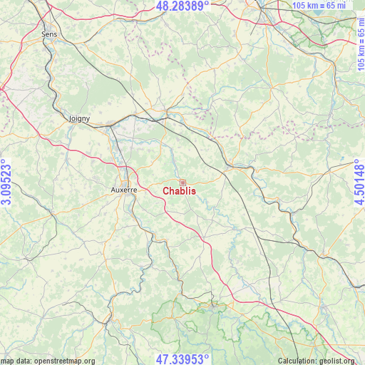
Chablis GPS coordinates[2]
47° 48' 49.896" North, 3° 47' 54.06" East
| Map corner | latitude | longitude |
|---|---|---|
| Upper-left | 48.28389°, | 3.09523° |
| Center: | 47.81386°, | 3.79835° |
| Lower-right: | 47.33953°, | 4.50148° |
| Map W x H: | 105×105 km | = 65.2×65.2mi |
| max Lat: | 51.07786° ⇑44% North |
| Chablis: | 47.81386° |
| min Lat: | ⇓56% South 41.3874° |
| min Long | Chablis | max Long |
| -5.08615° | 3.79835° | 9.52242° |
| W 66.3%⇐ | ⇒33.7% E |
Elevation
Elevation of Chablis is 140 m = 459 ft, and this is 53.7 m = 176 ft below average elevation for this country.
| Max E: |
2333 m = 7654 ft | 47.8% |
| Avg. | 193.7 m = 635 ft | |
| Chablis | 140 m = 459 ft | |
Min E: |
-1 m = -3 ft | 52.2% |
See also: France elevation on elevation.city.
Geographical zone
Chablis is located in North temperate zone (between Tropic of Cancer and the Arctic Circle). Distance of this North polar circle is 2084.8 km =1295.4 mi to North.| Distance of | km | miles | from Chablis |
|---|---|---|---|
| North Pole | 4690.7 | 2914.7 | to North |
| Arctic Circle | 2084.8 | 1295.4 | to North |
| Tropic Cancer | 2710.5 | 1684.2 | to South |
| Equator | 5316.4 | 3303.5 | to South |


Nearby cities:
15 places around Chablis: (largest is in red/bold)
• Augy
15 km =9.3 mi,  249°
249°
• Auxerre
17.1 km =10.6 mi,  264°
264°
• Cravant
16.6 km =10.3 mi,  208°
208°
• Flogny-la-Chapelle
16 km =9.9 mi,  18°
18°
• Héry
16 km =9.9 mi,  307°
307°
• Ligny-le-Châtel
10.1 km =6.3 mi,  342°
342°
• Maligny
6.7 km =4.2 mi, 337°
• Montigny-la-Resle
10.5 km =6.5 mi,  303°
303°
• Monéteau
16.6 km =10.3 mi,  283°
283°
• Pontigny
12 km =7.5 mi,  327°
327°
• Saint-Bris-le-Vineux
13.6 km =8.5 mi,  235°
235°
• Tonnerre
13.9 km =8.6 mi,  70°
70°
• Venoy
12.1 km =7.5 mi,  265°
265°
• Vermenton
17.3 km =10.7 mi,  195°
195°
• Épineuil
14.9 km =9.3 mi,  64°
64°
Sources, notices
• [Note1] Compared only with cities in France existing in our database
• [Src1] Map data: © OpenStreetMap contributors (CC-BY-SA)
• [Src2] Other city data from geonames.org with taken over terms of usage.
• [Src3] Geographical zone / Annual Mean Temperature by Robert A. Rohde @ Wikipedia
