Tonnerre geodata
Tonnerre (Bourgogne-Franche-Comté) is a populated place; located in France in Europe/Paris (GMT+2) time zone. With population of 5,352 people, there are 1841 cities with bigger population in this country. Compared to other cities in France, 56.7% of cities are located further ↓South; 67.6% of cities are located further ←West and 53.6% of cities have lower elevation than Tonnerre. Note1
Administrative division(s):
- Level 1: Bourgogne-Franche-Comté
- Level 2: Département de l'Yonne
- Level 3: Avallon
- Level 4: Tonnerre


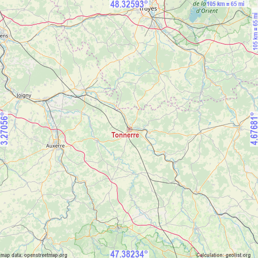
Tonnerre GPS coordinates[2]
47° 51' 22.608" North, 3° 58' 25.284" East
| Map corner | latitude | longitude |
|---|---|---|
| Upper-left | 48.32593°, | 3.27056° |
| Center: | 47.85628°, | 3.97369° |
| Lower-right: | 47.38234°, | 4.67681° |
| Map W x H: | 104.9×104.9 km | = 65.2×65.2mi |
| max Lat: | 51.07786° ⇑43.3% North |
| Tonnerre: | 47.85628° |
| min Lat: | ⇓56.7% South 41.3874° |
| min Long | Tonnerre | max Long |
| -5.08615° | 3.97369° | 9.52242° |
| W 67.6%⇐ | ⇒32.4% E |
Elevation
Elevation of Tonnerre is 145 m = 476 ft, and this is 48.7 m = 160 ft below average elevation for this country.
| Max E: |
2333 m = 7654 ft | 46.4% |
| Avg. | 193.7 m = 635 ft | |
| Tonnerre | 145 m = 476 ft | |
Min E: |
-1 m = -3 ft | 53.6% |
See also: France elevation on elevation.city.
Geographical zone
Tonnerre is located in North temperate zone (between Tropic of Cancer and the Arctic Circle). Distance of this North polar circle is 2080.1 km =1292.5 mi to North.| Distance of | km | miles | from Tonnerre |
|---|---|---|---|
| North Pole | 4685.9 | 2911.7 | to North |
| Arctic Circle | 2080.1 | 1292.5 | to North |
| Tropic Cancer | 2715.2 | 1687.1 | to South |
| Equator | 5321.1 | 3306.4 | to South |


Nearby cities:
15 places around Tonnerre: (largest is in red/bold)
• Ancy-le-Franc
16.8 km =10.4 mi,  122°
122°
• Chablis
13.9 km =8.6 mi,  250°
250°
• Chessy-les-Prés
19.1 km =11.9 mi,  346°
346°
• Ervy-le-Châtel
21.1 km =13.1 mi, 346°
• Flogny-la-Chapelle
13.1 km =8.1 mi,  322°
322°
• Germigny
21.1 km =13.1 mi, 317°
• Ligny-le-Châtel
16.8 km =10.4 mi,  286°
286°
• Lézinnes
10.5 km =6.5 mi,  125°
125°
• Maligny
15.7 km =9.8 mi,  275°
275°
• Montigny-la-Resle
21.9 km =13.6 mi,  272°
272°
• Noyers
18 km =11.2 mi,  174°
174°
• Pontigny
20.3 km =12.6 mi, 285°
• Tanlay
8.4 km =5.2 mi,  98°
98°
• Vergigny
22.9 km =14.2 mi,  303°
303°
• Épineuil
1.8 km =1.1 mi,  12°
12°
Sources, notices
• [Note1] Compared only with cities in France existing in our database
• [Src1] Map data: © OpenStreetMap contributors (CC-BY-SA)
• [Src2] Other city data from geonames.org with taken over terms of usage.
• [Src3] Geographical zone / Annual Mean Temperature by Robert A. Rohde @ Wikipedia
