Prissac geodata
Prissac (Centre) is a populated place; located in France in Europe/Paris (GMT+2) time zone. With population of 741 people, there are 11277 cities with bigger population in this country. Compared to other cities in France, 60% of cities are located further ↑North; 65.4% of cities are located further →East and 58.7% of cities have lower elevation than Prissac. Note1
Administrative division(s):
- Level 1: Centre
- Level 2: Département de l'Indre
- Level 3: Le Blanc
- Level 4: Prissac


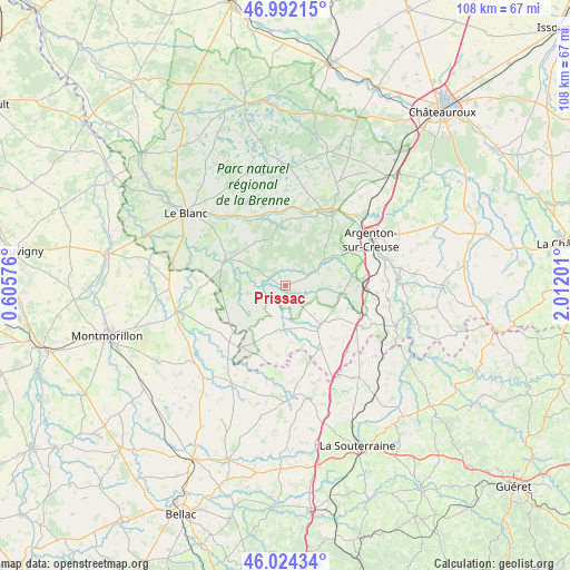
Prissac GPS coordinates[2]
46° 30' 37.44" North, 1° 18' 31.968" East
| Map corner | latitude | longitude |
|---|---|---|
| Upper-left | 46.99215°, | 0.60576° |
| Center: | 46.5104°, | 1.30888° |
| Lower-right: | 46.02434°, | 2.01201° |
| Map W x H: | 107.6×107.6 km | = 66.9×66.9mi |
| max Lat: | 51.07786° ⇑60% North |
| Prissac: | 46.5104° |
| min Lat: | ⇓40% South 41.3874° |
| min Long | Prissac | max Long |
| -5.08615° | 1.30888° | 9.52242° |
| W 34.6%⇐ | ⇒65.4% E |
Elevation
Elevation of Prissac is 164 m = 538 ft, and this is 29.7 m = 97 ft below average elevation for this country.
| Max E: |
2333 m = 7654 ft | 41.3% |
| Avg. | 193.7 m = 635 ft | |
| Prissac | 164 m = 538 ft | |
Min E: |
-1 m = -3 ft | 58.7% |
See also: France elevation on elevation.city.
Geographical zone
Prissac is located in North temperate zone (between Tropic of Cancer and the Arctic Circle). Distance of this North polar circle is 2229.7 km =1385.5 mi to North.| Distance of | km | miles | from Prissac |
|---|---|---|---|
| North Pole | 4835.6 | 3004.7 | to North |
| Arctic Circle | 2229.7 | 1385.5 | to North |
| Tropic Cancer | 2565.6 | 1594.2 | to South |
| Equator | 5171.5 | 3213.4 | to South |


Nearby cities:
15 places around Prissac: (largest is in red/bold)
• Argenton-sur-Creuse
18.4 km =11.4 mi,  61°
61°
• Bélâbre
12.4 km =7.7 mi,  291°
291°
• Chabenet
19.2 km =11.9 mi,  48°
48°
• Chaillac
8.5 km =5.3 mi,  185°
185°
• Ciron
13.9 km =8.6 mi,  339°
339°
• La Châtre-Langlin
12.9 km =8 mi,  151°
151°
• Le Pêchereau
19.7 km =12.2 mi,  67°
67°
• Lignac
8.5 km =5.3 mi,  234°
234°
• Parnac
12 km =7.5 mi,  121°
121°
• Rivarennes
15.2 km =9.4 mi,  23°
23°
• Ruffec
17 km =10.6 mi,  321°
321°
• Saint-Benoît-du-Sault
10 km =6.2 mi,  141°
141°
• Saint-Gaultier
16 km =9.9 mi,  29°
29°
• Saint-Marcel
18.6 km =11.6 mi, 56°
• Thenay
16.1 km =10 mi, 34°
Sources, notices
• [Note1] Compared only with cities in France existing in our database
• [Src1] Map data: © OpenStreetMap contributors (CC-BY-SA)
• [Src2] Other city data from geonames.org with taken over terms of usage.
• [Src3] Geographical zone / Annual Mean Temperature by Robert A. Rohde @ Wikipedia
