Cauroir geodata
Cauroir (Hauts-de-France) is a populated place; located in France in Europe/Paris (GMT+2) time zone. With population of 529 people, there are 14624 cities with bigger population in this country. Compared to other cities in France, 94.7% of cities are located further ↓South; 62% of cities are located further ←West and 76.6% of cities have higher elevation than Cauroir. Note1
Administrative division(s):
- Level 1: Hauts-de-France
- Level 2: Nord
- Level 3: Arrondissement de Cambrai
- Level 4: Cauroir


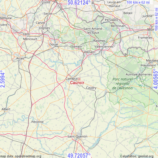
Cauroir GPS coordinates[2]
50° 10' 22.908" North, 3° 18' 9.108" East
| Map corner | latitude | longitude |
|---|---|---|
| Upper-left | 50.62124°, | 2.5994° |
| Center: | 50.17303°, | 3.30253° |
| Lower-right: | 49.72057°, | 4.00565° |
| Map W x H: | 100.1×100.1 km | = 62.2×62.2mi |
| max Lat: | 51.07786° ⇑5.3% North |
| Cauroir: | 50.17303° |
| min Lat: | ⇓94.7% South 41.3874° |
| min Long | Cauroir | max Long |
| -5.08615° | 3.30253° | 9.52242° |
| W 62%⇐ | ⇒38% E |
Elevation
Elevation of Cauroir is 63 m = 207 ft, and this is 130.7 m = 429 ft below average elevation for this country.
| Max E: |
2333 m = 7654 ft | 76.6% |
| Avg. | 193.7 m = 635 ft | |
| Cauroir | 63 m = 207 ft | |
Min E: |
-1 m = -3 ft | 23.4% |
See also: France elevation on elevation.city.
Geographical zone
Cauroir is located in North temperate zone (between Tropic of Cancer and the Arctic Circle). Distance of this North polar circle is 1822.5 km =1132.4 mi to North.| Distance of | km | miles | from Cauroir |
|---|---|---|---|
| North Pole | 4428.3 | 2751.6 | to North |
| Arctic Circle | 1822.5 | 1132.4 | to North |
| Tropic Cancer | 2972.8 | 1847.2 | to South |
| Equator | 5578.7 | 3466.4 | to South |


Nearby cities:
15 places around Cauroir: (largest is in red/bold)
• Avesnes-les-Aubert
6.5 km =4 mi,  62°
62°
• Awoingt
2.5 km =1.6 mi,  217°
217°
• Beauvois-en-Cambrésis
6.7 km =4.2 mi,  126°
126°
• Bévillers
6.5 km =4 mi,  105°
105°
• Cambrai
4.8 km =3 mi,  273°
273°
• Carnières
3.2 km =2 mi,  99°
99°
• Cattenières
4.8 km =3 mi,  151°
151°
• Escaudœuvres
3.9 km =2.4 mi,  319°
319°
• Iwuy
6.8 km =4.2 mi,  10°
10°
• Naves
3.5 km =2.2 mi,  16°
16°
• Neuville-Saint-Rémy
5.8 km =3.6 mi,  284°
284°
• Niergnies
4.4 km =2.7 mi,  229°
229°
• Ramillies
4.6 km =2.9 mi, 320°
• Rieux-en-Cambrésis
4.7 km =2.9 mi,  49°
49°
• Tilloy-lez-Cambrai
6.8 km =4.2 mi,  296°
296°
Sources, notices
• [Note1] Compared only with cities in France existing in our database
• [Src1] Map data: © OpenStreetMap contributors (CC-BY-SA)
• [Src2] Other city data from geonames.org with taken over terms of usage.
• [Src3] Geographical zone / Annual Mean Temperature by Robert A. Rohde @ Wikipedia
