Bacilly geodata
Bacilly (Normandy) is a populated place; located in France in Europe/Paris (GMT+2) time zone. With population of 680 people, there are 12068 cities with bigger population in this country. Compared to other cities in France, 73.3% of cities are located further ↓South; 91.9% of cities are located further →East and 90.3% of cities have higher elevation than Bacilly. Note1


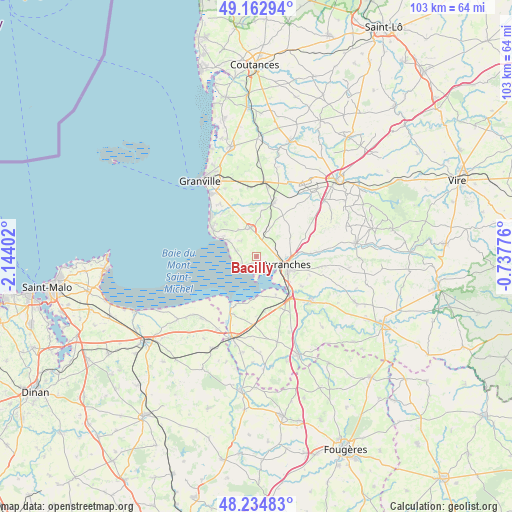
Bacilly GPS coordinates[2]
48° 42' 3.672" North, 1° 26' 27.204" West
| Map corner | latitude | longitude |
|---|---|---|
| Upper-left | 49.16294°, | -2.14402° |
| Center: | 48.70102°, | -1.44089° |
| Lower-right: | 48.23483°, | -0.73776° |
| Map W x H: | 103.2×103.2 km | = 64.1×64.1mi |
| max Lat: | 51.07786° ⇑26.7% North |
| Bacilly: | 48.70102° |
| min Lat: | ⇓73.3% South 41.3874° |
| min Long | Bacilly | max Long |
| -5.08615° | -1.44089° | 9.52242° |
| W 8.1%⇐ | ⇒91.9% E |
Elevation
Elevation of Bacilly is 29 m = 95 ft, and this is 164.7 m = 540 ft below average elevation for this country.
| Max E: |
2333 m = 7654 ft | 90.3% |
| Avg. | 193.7 m = 635 ft | |
| Bacilly | 29 m = 95 ft | |
Min E: |
-1 m = -3 ft | 9.7% |
See also: France elevation on elevation.city.
Geographical zone
Bacilly is located in North temperate zone (between Tropic of Cancer and the Arctic Circle). Distance of this North polar circle is 1986.1 km =1234.1 mi to North.| Distance of | km | miles | from Bacilly |
|---|---|---|---|
| North Pole | 4592 | 2853.3 | to North |
| Arctic Circle | 1986.1 | 1234.1 | to North |
| Tropic Cancer | 2809.1 | 1745.5 | to South |
| Equator | 5415 | 3364.7 | to South |


Nearby cities:
15 places around Bacilly: (largest is in red/bold)
• Avranches
6.4 km =4 mi,  106°
106°
• Carolles
10.4 km =6.5 mi,  302°
302°
• Dragey-Ronthon
4.7 km =2.9 mi,  291°
291°
• Jullouville
12.3 km =7.6 mi,  312°
312°
• La Haye-Pesnel
11 km =6.8 mi,  17°
17°
• Le Val-Saint-Père
6.4 km =4 mi,  132°
132°
• Lolif
5 km =3.1 mi,  44°
44°
• Marcey-les-Grèves
3.7 km =2.3 mi,  97°
97°
• Saint-Loup
11.3 km =7 mi, 109°
• Saint-Martin-des-Champs
8.6 km =5.3 mi, 114°
• Saint-Quentin-sur-le-Homme
10.8 km =6.7 mi,  123°
123°
• Saint-Senier-sous-Avranches
8.3 km =5.2 mi, 103°
• Sartilly
5.8 km =3.6 mi,  348°
348°
• Tirepied
13 km =8.1 mi,  85°
85°
• Vains
3 km =1.9 mi,  138°
138°
Sources, notices
• [Note1] Compared only with cities in France existing in our database
• [Src1] Map data: © OpenStreetMap contributors (CC-BY-SA)
• [Src2] Other city data from geonames.org with taken over terms of usage.
• [Src3] Geographical zone / Annual Mean Temperature by Robert A. Rohde @ Wikipedia
