Carnoules geodata
Carnoules (Provence-Alpes-Côte d'Azur) is a populated place; located in France in Europe/Paris (GMT+2) time zone. With population of 2,810 people, there are 3470 cities with bigger population in this country. Compared to other cities in France, 95.6% of cities are located further ↑North; 89.2% of cities are located further ←West and 69.9% of cities have lower elevation than Carnoules. Note1
Administrative division(s):
- Level 1: Provence-Alpes-Côte d'Azur
- Level 2: Var
- Level 3: Arrondissement de Brignoles
- Level 4: Carnoules


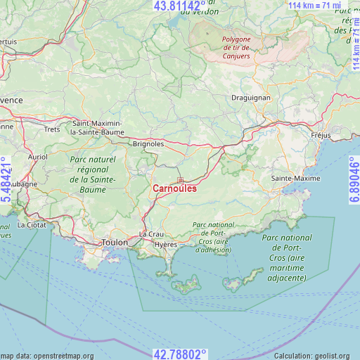
Carnoules GPS coordinates[2]
43° 18' 6.732" North, 6° 11' 14.388" East
| Map corner | latitude | longitude |
|---|---|---|
| Upper-left | 43.81142°, | 5.48421° |
| Center: | 43.30187°, | 6.18733° |
| Lower-right: | 42.78802°, | 6.89046° |
| Map W x H: | 113.8×113.8 km | = 70.7×70.7mi |
| max Lat: | 51.07786° ⇑95.6% North |
| Carnoules: | 43.30187° |
| min Lat: | ⇓4.4% South 41.3874° |
| min Long | Carnoules | max Long |
| -5.08615° | 6.18733° | 9.52242° |
| W 89.2%⇐ | ⇒10.8% E |
Elevation
Elevation of Carnoules is 219 m = 719 ft, and this is 25.3 m = 83 ft above average elevation for this country.
| Max E: |
2333 m = 7654 ft | 30.1% |
| Carnoules | 219 m 719 ft | |
| Avg. | 193.7 m = 635 ft | |
Min E: |
-1 m = -3 ft | 69.9% |
See also: France elevation on elevation.city.
Geographical zone
Carnoules is located in North temperate zone (between Tropic of Cancer and the Arctic Circle). Distance of this Northern Tropic circle is 2208.8 km =1372.5 mi to South.| Distance of | km | miles | from Carnoules |
|---|---|---|---|
| North Pole | 5192.3 | 3226.3 | to North |
| Arctic Circle | 2586.5 | 1607.2 | to North |
| Tropic Cancer | 2208.8 | 1372.5 | to South |
| Equator | 4814.7 | 2991.7 | to South |


Nearby cities:
15 places around Carnoules: (largest is in red/bold)
• Besse-sur-Issole
5.3 km =3.3 mi,  350°
350°
• Cabasse
14.1 km =8.8 mi,  10°
10°
• Camps-la-Source
11.9 km =7.4 mi,  321°
321°
• Collobrières
12.2 km =7.6 mi,  126°
126°
• Cuers
11.8 km =7.3 mi,  232°
232°
• Flassans-sur-Issole
7.9 km =4.9 mi,  20°
20°
• Forcalqueiret
9.2 km =5.7 mi,  294°
294°
• Garéoult
11.8 km =7.3 mi,  284°
284°
• Gonfaron
8.5 km =5.3 mi,  76°
76°
• Les Mayons
13.9 km =8.6 mi, 84°
• Pierrefeu-du-Var
9.3 km =5.8 mi,  201°
201°
• Pignans
3.2 km =2 mi,  92°
92°
• Puget-Ville
4.4 km =2.7 mi,  251°
251°
• Rocbaron
8.8 km =5.5 mi, 275°
• Sainte-Anastasie-sur-Issole
6.8 km =4.2 mi,  311°
311°
Sources, notices
• [Note1] Compared only with cities in France existing in our database
• [Src1] Map data: © OpenStreetMap contributors (CC-BY-SA)
• [Src2] Other city data from geonames.org with taken over terms of usage.
• [Src3] Geographical zone / Annual Mean Temperature by Robert A. Rohde @ Wikipedia
