Gonfaron geodata
Gonfaron (Provence-Alpes-Côte d'Azur) is a populated place; located in France in Europe/Paris (GMT+2) time zone. With population of 3,636 people, there are 2689 cities with bigger population in this country. Compared to other cities in France, 95.2% of cities are located further ↑North; 90.1% of cities are located further ←West and 57.6% of cities have lower elevation than Gonfaron. Note1
Administrative division(s):
- Level 1: Provence-Alpes-Côte d'Azur
- Level 2: Var
- Level 3: Arrondissement de Brignoles
- Level 4: Gonfaron


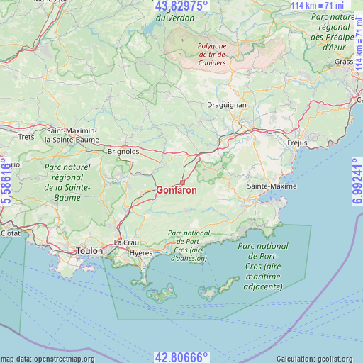
Gonfaron GPS coordinates[2]
43° 19' 13.296" North, 6° 17' 21.444" East
| Map corner | latitude | longitude |
|---|---|---|
| Upper-left | 43.82975°, | 5.58616° |
| Center: | 43.32036°, | 6.28929° |
| Lower-right: | 42.80666°, | 6.99241° |
| Map W x H: | 113.8×113.8 km | = 70.7×70.7mi |
| max Lat: | 51.07786° ⇑95.2% North |
| Gonfaron: | 43.32036° |
| min Lat: | ⇓4.8% South 41.3874° |
| min Long | Gonfaron | max Long |
| -5.08615° | 6.28929° | 9.52242° |
| W 90.1%⇐ | ⇒9.9% E |
Elevation
Elevation of Gonfaron is 160 m = 525 ft, and this is 33.7 m = 111 ft below average elevation for this country.
| Max E: |
2333 m = 7654 ft | 42.4% |
| Avg. | 193.7 m = 635 ft | |
| Gonfaron | 160 m = 525 ft | |
Min E: |
-1 m = -3 ft | 57.6% |
See also: France elevation on elevation.city.
Geographical zone
Gonfaron is located in North temperate zone (between Tropic of Cancer and the Arctic Circle). Distance of this Northern Tropic circle is 2210.9 km =1373.8 mi to South.| Distance of | km | miles | from Gonfaron |
|---|---|---|---|
| North Pole | 5190.3 | 3225.1 | to North |
| Arctic Circle | 2584.4 | 1605.9 | to North |
| Tropic Cancer | 2210.9 | 1373.8 | to South |
| Equator | 4816.8 | 2993 | to South |


Nearby cities:
15 places around Gonfaron: (largest is in red/bold)
• Besse-sur-Issole
9.7 km =6 mi,  289°
289°
• Cabasse
13.1 km =8.1 mi,  334°
334°
• Carnoules
8.5 km =5.3 mi,  256°
256°
• Collobrières
9.4 km =5.8 mi,  170°
170°
• Flassans-sur-Issole
7.7 km =4.8 mi,  314°
314°
• La Garde-Freinet
14.6 km =9.1 mi,  91°
91°
• Le Cannet-des-Maures
9 km =5.6 mi,  26°
26°
• Le Luc
8.5 km =5.3 mi,  12°
12°
• Le Thoronet
14.7 km =9.1 mi,  4°
4°
• Les Mayons
5.6 km =3.5 mi,  98°
98°
• Pierrefeu-du-Var
15.8 km =9.8 mi,  227°
227°
• Pignans
5.5 km =3.4 mi,  246°
246°
• Puget-Ville
12.9 km =8 mi, 254°
• Sainte-Anastasie-sur-Issole
13.5 km =8.4 mi,  280°
280°
• Vidauban
16.6 km =10.3 mi,  44°
44°
Sources, notices
• [Note1] Compared only with cities in France existing in our database
• [Src1] Map data: © OpenStreetMap contributors (CC-BY-SA)
• [Src2] Other city data from geonames.org with taken over terms of usage.
• [Src3] Geographical zone / Annual Mean Temperature by Robert A. Rohde @ Wikipedia
