Bersée geodata
Bersée (Hauts-de-France) is a populated place; located in France in Europe/Paris (GMT+2) time zone. With population of 2,178 people, there are 4407 cities with bigger population in this country. Compared to other cities in France, 97.1% of cities are located further ↓South; 59.9% of cities are located further ←West and 80.2% of cities have higher elevation than Bersée. Note1
Administrative division(s):
- Level 1: Hauts-de-France
- Level 2: Nord
- Level 3: Arrondissement de Lille
- Level 4: Bersée


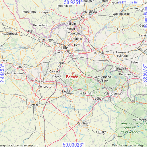
Bersée GPS coordinates[2]
50° 28' 47.208" North, 3° 8' 51.54" East
| Map corner | latitude | longitude |
|---|---|---|
| Upper-left | 50.9251°, | 2.44453° |
| Center: | 50.47978°, | 3.14765° |
| Lower-right: | 50.03023°, | 3.85078° |
| Map W x H: | 99.5×99.5 km | = 61.8×61.8mi |
| max Lat: | 51.07786° ⇑2.9% North |
| Bersée: | 50.47978° |
| min Lat: | ⇓97.1% South 41.3874° |
| min Long | Bersée | max Long |
| -5.08615° | 3.14765° | 9.52242° |
| W 59.9%⇐ | ⇒40.1% E |
Elevation
Elevation of Bersée is 54 m = 177 ft, and this is 139.7 m = 458 ft below average elevation for this country.
| Max E: |
2333 m = 7654 ft | 80.2% |
| Avg. | 193.7 m = 635 ft | |
| Bersée | 54 m = 177 ft | |
Min E: |
-1 m = -3 ft | 19.8% |
See also: France elevation on elevation.city.
Geographical zone
Bersée is located in North temperate zone (between Tropic of Cancer and the Arctic Circle). Distance of this North polar circle is 1788.3 km =1111.2 mi to North.| Distance of | km | miles | from Bersée |
|---|---|---|---|
| North Pole | 4394.2 | 2730.4 | to North |
| Arctic Circle | 1788.3 | 1111.2 | to North |
| Tropic Cancer | 3006.9 | 1868.4 | to South |
| Equator | 5612.8 | 3487.6 | to South |


Nearby cities:
15 places around Bersée: (largest is in red/bold)
• Cappelle-en-Pévèle
3.8 km =2.4 mi,  26°
26°
• Coutiches
4.8 km =3 mi,  124°
124°
• Ennevelin
6.9 km =4.3 mi,  349°
349°
• Faumont
2.3 km =1.4 mi,  198°
198°
• La Neuville
7.2 km =4.5 mi,  281°
281°
• Mons-en-Pévèle
3.5 km =2.2 mi,  269°
269°
• Mérignies
3.9 km =2.4 mi,  318°
318°
• Orchies
6.2 km =3.9 mi,  103°
103°
• Pont-à-Marcq
5.3 km =3.3 mi,  333°
333°
• Raimbeaucourt
6.3 km =3.9 mi,  217°
217°
• Roost-Warendin
7.4 km =4.6 mi, 204°
• Râches
7 km =4.3 mi,  186°
186°
• Templeuve-en-Pévèle
5.3 km =3.3 mi,  23°
23°
• Thumeries
6.6 km =4.1 mi, 266°
• Tourmignies
5.4 km =3.4 mi,  304°
304°
Sources, notices
• [Note1] Compared only with cities in France existing in our database
• [Src1] Map data: © OpenStreetMap contributors (CC-BY-SA)
• [Src2] Other city data from geonames.org with taken over terms of usage.
• [Src3] Geographical zone / Annual Mean Temperature by Robert A. Rohde @ Wikipedia
