Arces-Dilo geodata
Arces-Dilo (Bourgogne-Franche-Comté) is a populated place; located in France in Europe/Paris (GMT+2) time zone. With population of 620 people, there are 12983 cities with bigger population in this country. Compared to other cities in France, 60.9% of cities are located further ↓South; 65% of cities are located further ←West and 75.9% of cities have lower elevation than Arces-Dilo. Note1
Administrative division(s):
- Level 1: Bourgogne-Franche-Comté
- Level 2: Département de l'Yonne
- Level 3: Arrondissement de Sens
- Level 4: Arces-Dilo


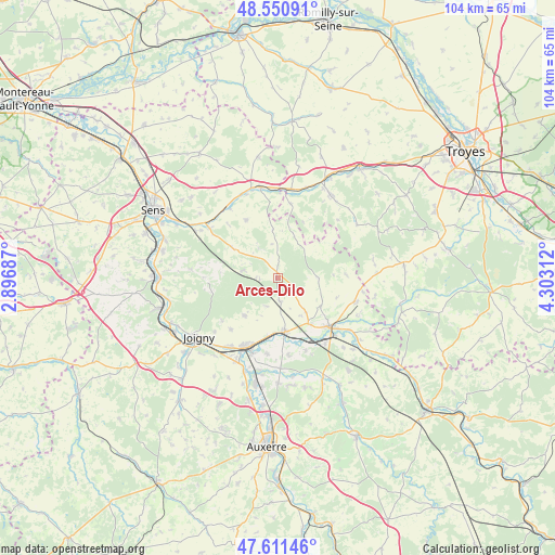
Arces-Dilo GPS coordinates[2]
48° 4' 59.988" North, 3° 36' 0" East
| Map corner | latitude | longitude |
|---|---|---|
| Upper-left | 48.55091°, | 2.89687° |
| Center: | 48.08333°, | 3.6° |
| Lower-right: | 47.61146°, | 4.30312° |
| Map W x H: | 104.5×104.5 km | = 64.9×64.9mi |
| max Lat: | 51.07786° ⇑39.1% North |
| Arces-Dilo: | 48.08333° |
| min Lat: | ⇓60.9% South 41.3874° |
| min Long | Arces-Dilo | max Long |
| -5.08615° | 3.6° | 9.52242° |
| W 65%⇐ | ⇒35% E |
Elevation
Elevation of Arces-Dilo is 256 m = 840 ft, and this is 62.3 m = 204 ft above average elevation for this country.
| Max E: |
2333 m = 7654 ft | 24.1% |
| Arces-Dilo | 256 m 840 ft | |
| Avg. | 193.7 m = 635 ft | |
Min E: |
-1 m = -3 ft | 75.9% |
See also: France elevation on elevation.city.
Geographical zone
Arces-Dilo is located in North temperate zone (between Tropic of Cancer and the Arctic Circle). Distance of this North polar circle is 2054.8 km =1276.8 mi to North.| Distance of | km | miles | from Arces-Dilo |
|---|---|---|---|
| North Pole | 4660.7 | 2896 | to North |
| Arctic Circle | 2054.8 | 1276.8 | to North |
| Tropic Cancer | 2740.4 | 1702.8 | to South |
| Equator | 5346.4 | 3322.1 | to South |


Nearby cities:
15 places around Arces-Dilo: (largest is in red/bold)
• Brienon-sur-Armançon
10.4 km =6.5 mi,  173°
173°
• Brion
13.2 km =8.2 mi,  222°
222°
• Bussy-en-Othe
9.6 km =6 mi, 222°
• Cerisiers
10.2 km =6.3 mi,  303°
303°
• Chailley
7.5 km =4.7 mi,  90°
90°
• Champlost
8.3 km =5.2 mi,  141°
141°
• Dixmont
13.8 km =8.6 mi,  269°
269°
• Migennes
14.5 km =9 mi,  204°
204°
• Mont-Saint-Sulpice
14.6 km =9.1 mi, 172°
• Neuvy-Sautour
15.2 km =9.4 mi,  107°
107°
• Ormoy
14.6 km =9.1 mi,  187°
187°
• Saint-Florentin
13.1 km =8.1 mi,  134°
134°
• Turny
12.1 km =7.5 mi,  116°
116°
• Venizy
9.8 km =6.1 mi, 123°
• Vergigny
15.3 km =9.5 mi, 144°
Sources, notices
• [Note1] Compared only with cities in France existing in our database
• [Src1] Map data: © OpenStreetMap contributors (CC-BY-SA)
• [Src2] Other city data from geonames.org with taken over terms of usage.
• [Src3] Geographical zone / Annual Mean Temperature by Robert A. Rohde @ Wikipedia
