Ferrières-sur-Sichon geodata
Ferrières-sur-Sichon (Auvergne-Rhône-Alpes) is a populated place; located in France in Europe/Paris (GMT+2) time zone. With population of 574 people, there are 13763 cities with bigger population in this country. Compared to other cities in France, 66% of cities are located further ↑North; 65.4% of cities are located further ←West and 95.2% of cities have lower elevation than Ferrières-sur-Sichon. Note1
Administrative division(s):
- Level 1: Auvergne-Rhône-Alpes
- Level 2: Département de l'Allier
- Level 3: Arrondissement de Vichy
- Level 4: Ferrières-sur-Sichon
Current local time in Ferrières-sur-Sichon:
01:48 PM, WednesdayDifference from your time zone: hours


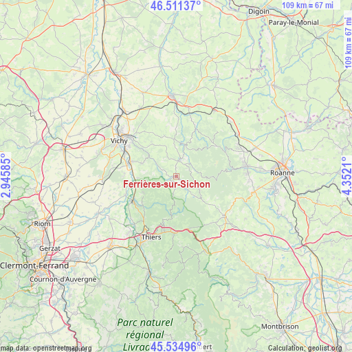
Ferrières-sur-Sichon GPS coordinates[2]
46° 1' 31.152" North, 3° 38' 56.328" East
| Map corner | latitude | longitude |
|---|---|---|
| Upper-left | 46.51137°, | 2.94585° |
| Center: | 46.02532°, | 3.64898° |
| Lower-right: | 45.53496°, | 4.3521° |
| Map W x H: | 108.6×108.6 km | = 67.5×67.5mi |
| max Lat: | 51.07786° ⇑66% North |
| Ferrières-sur-Sichon: | 46.02532° |
| min Lat: | ⇓34% South 41.3874° |
| min Long | Ferrières-sur- | max Long |
| -5.08615° | 3.64898° | 9.52242° |
| W 65.4%⇐ | ⇒34.6% E |
Elevation
Elevation of Ferrières-sur-Sichon is 600 m = 1969 ft, and this is 406.3 m = 1333 ft above average elevation for this country.
| Max E: |
2333 m = 7654 ft | 4.8% |
| Ferrières-sur-Sichon | 600 m 1969 ft | |
| Avg. | 193.7 m = 635 ft | |
Min E: |
-1 m = -3 ft | 95.2% |
See also: France elevation on elevation.city.
Geographical zone
Ferrières-sur-Sichon is located in North temperate zone (between Tropic of Cancer and the Arctic Circle). Distance of this North polar circle is 2283.6 km =1419 mi to North.| Distance of | km | miles | from Ferrières-sur-Sichon |
|---|---|---|---|
| North Pole | 4889.5 | 3038.2 | to North |
| Arctic Circle | 2283.6 | 1419 | to North |
| Tropic Cancer | 2511.6 | 1560.6 | to South |
| Equator | 5117.5 | 3179.9 | to South |


Nearby cities:
15 places around Ferrières-sur-Sichon: (largest is in red/bold)
• Arconsat
16 km =9.9 mi,  161°
161°
• Arfeuilles
15.8 km =9.8 mi,  22°
22°
• Busset
11.3 km =7 mi,  291°
291°
• Chabreloche
16.7 km =10.4 mi,  167°
167°
• Châteldon
11.3 km =7 mi,  241°
241°
• Le Mayet-de-Montagne
5.2 km =3.2 mi, 15°
• Mariol
11.7 km =7.3 mi,  267°
267°
• Molles
11.9 km =7.4 mi,  323°
323°
• Palladuc
13.5 km =8.4 mi,  186°
186°
• Paslières
15.9 km =9.9 mi,  227°
227°
• Puy-Guillaume
15.3 km =9.5 mi, 241°
• Ris
11.4 km =7.1 mi,  255°
255°
• Saint-Priest-Bramefant
16.1 km =10 mi, 271°
• Saint-Rémy-sur-Durolle
15.9 km =9.9 mi,  195°
195°
• Saint-Yorre
15 km =9.3 mi, 287°
Sources, notices
• [Note1] Compared only with cities in France existing in our database
• [Src1] Map data: © OpenStreetMap contributors (CC-BY-SA)
• [Src2] Other city data from geonames.org with taken over terms of usage.
• [Src3] Geographical zone / Annual Mean Temperature by Robert A. Rohde @ Wikipedia
