Brugheas geodata
Brugheas (Auvergne-Rhône-Alpes) is a populated place; located in France in Europe/Paris (GMT+2) time zone. With population of 1,271 people, there are 7176 cities with bigger population in this country. Compared to other cities in France, 65.3% of cities are located further ↑North; 62.9% of cities are located further ←West and 83.3% of cities have lower elevation than Brugheas. Note1
Administrative division(s):
- Level 1: Auvergne-Rhône-Alpes
- Level 2: Département de l'Allier
- Level 3: Arrondissement de Vichy
- Level 4: Brugheas


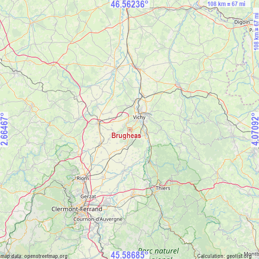
Brugheas GPS coordinates[2]
46° 4' 36.336" North, 3° 22' 4.08" East
| Map corner | latitude | longitude |
|---|---|---|
| Upper-left | 46.56236°, | 2.66467° |
| Center: | 46.07676°, | 3.3678° |
| Lower-right: | 45.58685°, | 4.07092° |
| Map W x H: | 108.5×108.5 km | = 67.4×67.4mi |
| max Lat: | 51.07786° ⇑65.3% North |
| Brugheas: | 46.07676° |
| min Lat: | ⇓34.7% South 41.3874° |
| min Long | Brugheas | max Long |
| -5.08615° | 3.3678° | 9.52242° |
| W 62.9%⇐ | ⇒37.1% E |
Elevation
Elevation of Brugheas is 325 m = 1066 ft, and this is 131.3 m = 431 ft above average elevation for this country.
| Max E: |
2333 m = 7654 ft | 16.7% |
| Brugheas | 325 m 1066 ft | |
| Avg. | 193.7 m = 635 ft | |
Min E: |
-1 m = -3 ft | 83.3% |
See also: France elevation on elevation.city.
Geographical zone
Brugheas is located in North temperate zone (between Tropic of Cancer and the Arctic Circle). Distance of this North polar circle is 2277.9 km =1415.4 mi to North.| Distance of | km | miles | from Brugheas |
|---|---|---|---|
| North Pole | 4883.8 | 3034.7 | to North |
| Arctic Circle | 2277.9 | 1415.4 | to North |
| Tropic Cancer | 2517.3 | 1564.2 | to South |
| Equator | 5123.3 | 3183.5 | to South |


Nearby cities:
15 places around Brugheas: (largest is in red/bold)
• Abrest
6.4 km =4 mi,  67°
67°
• Bellerive-sur-Allier
5.2 km =3.2 mi,  32°
32°
• Biozat
7.4 km =4.6 mi,  270°
270°
• Charmeil
9.6 km =6 mi,  11°
11°
• Cognat-Lyonne
5.7 km =3.5 mi,  308°
308°
• Cusset
9.4 km =5.8 mi,  46°
46°
• Effiat
9.6 km =6 mi,  244°
244°
• Espinasse-Vozelle
6.5 km =4 mi,  328°
328°
• Hauterive
6.2 km =3.9 mi,  77°
77°
• Pragoulin
3.2 km =2 mi,  141°
141°
• Randan
6.6 km =4.1 mi,  188°
188°
• Saint-Priest-Bramefant
7.8 km =4.8 mi,  133°
133°
• Saint-Yorre
7.5 km =4.7 mi,  99°
99°
• Serbannes
2.5 km =1.6 mi,  343°
343°
• Vichy
7.2 km =4.5 mi,  38°
38°
Sources, notices
• [Note1] Compared only with cities in France existing in our database
• [Src1] Map data: © OpenStreetMap contributors (CC-BY-SA)
• [Src2] Other city data from geonames.org with taken over terms of usage.
• [Src3] Geographical zone / Annual Mean Temperature by Robert A. Rohde @ Wikipedia
