Abrest geodata
Abrest (Auvergne-Rhône-Alpes) is a populated place; located in France in Europe/Paris (GMT+2) time zone. With population of 2,503 people, there are 3891 cities with bigger population in this country. Compared to other cities in France, 65.1% of cities are located further ↑North; 63.7% of cities are located further ←West and 83.2% of cities have lower elevation than Abrest. Note1
Administrative division(s):
- Level 1: Auvergne-Rhône-Alpes
- Level 2: Département de l'Allier
- Level 3: Arrondissement de Vichy
- Level 4: Abrest


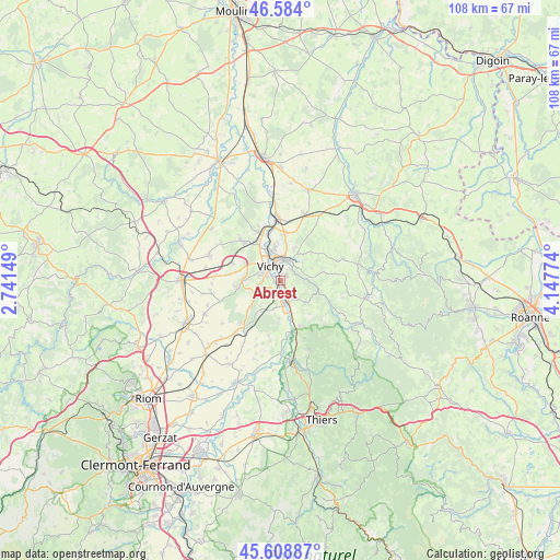
Abrest GPS coordinates[2]
46° 5' 54.924" North, 3° 26' 40.596" East
| Map corner | latitude | longitude |
|---|---|---|
| Upper-left | 46.584°, | 2.74149° |
| Center: | 46.09859°, | 3.44461° |
| Lower-right: | 45.60887°, | 4.14774° |
| Map W x H: | 108.4×108.4 km | = 67.4×67.4mi |
| max Lat: | 51.07786° ⇑65.1% North |
| Abrest: | 46.09859° |
| min Lat: | ⇓34.9% South 41.3874° |
| min Long | Abrest | max Long |
| -5.08615° | 3.44461° | 9.52242° |
| W 63.7%⇐ | ⇒36.3% E |
Elevation
Elevation of Abrest is 324 m = 1063 ft, and this is 130.3 m = 427 ft above average elevation for this country.
| Max E: |
2333 m = 7654 ft | 16.8% |
| Abrest | 324 m 1063 ft | |
| Avg. | 193.7 m = 635 ft | |
Min E: |
-1 m = -3 ft | 83.2% |
See also: France elevation on elevation.city.
Geographical zone
Abrest is located in North temperate zone (between Tropic of Cancer and the Arctic Circle). Distance of this North polar circle is 2275.5 km =1413.9 mi to North.| Distance of | km | miles | from Abrest |
|---|---|---|---|
| North Pole | 4881.4 | 3033.2 | to North |
| Arctic Circle | 2275.5 | 1413.9 | to North |
| Tropic Cancer | 2519.8 | 1565.7 | to South |
| Equator | 5125.7 | 3185 | to South |


Nearby cities:
15 places around Abrest: (largest is in red/bold)
• Bellerive-sur-Allier
3.7 km =2.3 mi,  302°
302°
• Brugheas
6.4 km =4 mi,  247°
247°
• Busset
6.6 km =4.1 mi,  127°
127°
• Charmeil
8 km =5 mi,  330°
330°
• Creuzier-le-Neuf
9.3 km =5.8 mi,  2°
2°
• Creuzier-le-Vieux
7.2 km =4.5 mi,  352°
352°
• Cusset
4.1 km =2.5 mi,  12°
12°
• Hauterive
1.1 km =0.7 mi,  173°
173°
• Mariol
9.6 km =6 mi,  155°
155°
• Molles
8.9 km =5.5 mi,  80°
80°
• Pragoulin
6.3 km =3.9 mi,  218°
218°
• Saint-Priest-Bramefant
7.8 km =4.8 mi,  182°
182°
• Saint-Yorre
3.9 km =2.4 mi, 157°
• Serbannes
6.6 km =4.1 mi,  270°
270°
• Vichy
3.5 km =2.2 mi,  335°
335°
Sources, notices
• [Note1] Compared only with cities in France existing in our database
• [Src1] Map data: © OpenStreetMap contributors (CC-BY-SA)
• [Src2] Other city data from geonames.org with taken over terms of usage.
• [Src3] Geographical zone / Annual Mean Temperature by Robert A. Rohde @ Wikipedia
