Seugy geodata
Seugy (Île-de-France) is a populated place; located in France in Europe/Paris (GMT+2) time zone. With population of 1,108 people, there are 8076 cities with bigger population in this country. Compared to other cities in France, 82.7% of cities are located further ↓South; 51.2% of cities are located further →East and 71% of cities have higher elevation than Seugy. Note1
Administrative division(s):
- Level 1: Île-de-France
- Level 2: Département du Val-d’Oise
- Level 3: Arrondissement de Sarcelles
- Level 4: Seugy


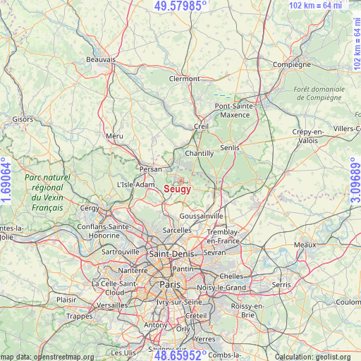
Seugy GPS coordinates[2]
49° 7' 18.552" North, 2° 23' 37.572" East
| Map corner | latitude | longitude |
|---|---|---|
| Upper-left | 49.57985°, | 1.69064° |
| Center: | 49.12182°, | 2.39377° |
| Lower-right: | 48.65952°, | 3.09689° |
| Map W x H: | 102.3×102.3 km | = 63.6×63.6mi |
| max Lat: | 51.07786° ⇑17.3% North |
| Seugy: | 49.12182° |
| min Lat: | ⇓82.7% South 41.3874° |
| min Long | Seugy | max Long |
| -5.08615° | 2.39377° | 9.52242° |
| W 48.8%⇐ | ⇒51.2% E |
Elevation
Elevation of Seugy is 76 m = 249 ft, and this is 117.7 m = 386 ft below average elevation for this country.
| Max E: |
2333 m = 7654 ft | 71% |
| Avg. | 193.7 m = 635 ft | |
| Seugy | 76 m = 249 ft | |
Min E: |
-1 m = -3 ft | 29% |
See also: France elevation on elevation.city.
Geographical zone
Seugy is located in North temperate zone (between Tropic of Cancer and the Arctic Circle). Distance of this North polar circle is 1939.3 km =1205 mi to North.| Distance of | km | miles | from Seugy |
|---|---|---|---|
| North Pole | 4545.2 | 2824.3 | to North |
| Arctic Circle | 1939.3 | 1205 | to North |
| Tropic Cancer | 2855.9 | 1774.6 | to South |
| Equator | 5461.8 | 3393.8 | to South |


Nearby cities:
15 places around Seugy: (largest is in red/bold)
• Asnières-sur-Oise
3.1 km =1.9 mi,  295°
295°
• Bellefontaine
5.9 km =3.7 mi,  116°
116°
• Belloy-en-France
4.1 km =2.5 mi,  203°
203°
• Boran-sur-Oise
5.7 km =3.5 mi,  332°
332°
• Bruyères-sur-Oise
6.3 km =3.9 mi,  308°
308°
• Chaumontel
2.8 km =1.7 mi,  83°
83°
• Coye-la-Forêt
6 km =3.7 mi,  67°
67°
• Gouvieux
7.4 km =4.6 mi,  11°
11°
• Lamorlaye
5.9 km =3.7 mi,  40°
40°
• Luzarches
2.3 km =1.4 mi,  114°
114°
• Mareil-en-France
6.3 km =3.9 mi,  158°
158°
• Noisy-sur-Oise
4.9 km =3 mi,  290°
290°
• Saint-Martin-du-Tertre
3.9 km =2.4 mi,  245°
245°
• Viarmes
2 km =1.2 mi, 300°
• Villaines-sous-Bois
5.7 km =3.5 mi,  207°
207°
Sources, notices
• [Note1] Compared only with cities in France existing in our database
• [Src1] Map data: © OpenStreetMap contributors (CC-BY-SA)
• [Src2] Other city data from geonames.org with taken over terms of usage.
• [Src3] Geographical zone / Annual Mean Temperature by Robert A. Rohde @ Wikipedia
