Asnières-sur-Oise geodata
Asnières-sur-Oise (Île-de-France) is a populated place; located in France in Europe/Paris (GMT+2) time zone. With population of 2,631 people, there are 3704 cities with bigger population in this country. Compared to other cities in France, 83% of cities are located further ↓South; 51.7% of cities are located further →East and 83.8% of cities have higher elevation than Asnières-sur-Oise. Note1
Administrative division(s):
- Level 1: Île-de-France
- Level 2: Département du Val-d’Oise
- Level 3: Arrondissement de Sarcelles
- Level 4: Asnières-sur-Oise


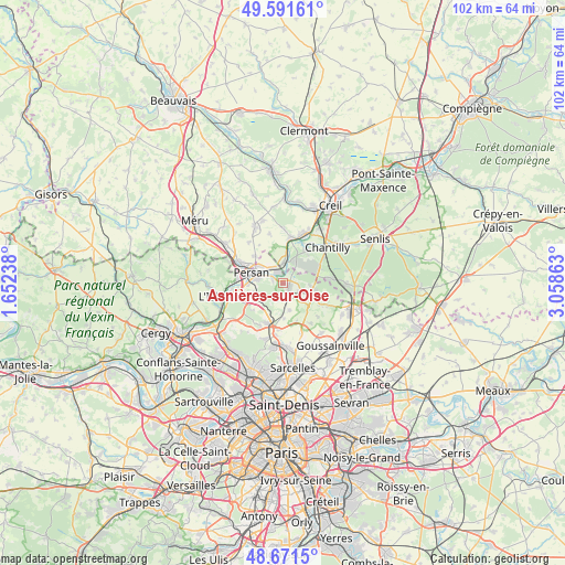
Asnières-sur-Oise GPS coordinates[2]
49° 8' 1.284" North, 2° 21' 19.836" East
| Map corner | latitude | longitude |
|---|---|---|
| Upper-left | 49.59161°, | 1.65238° |
| Center: | 49.13369°, | 2.35551° |
| Lower-right: | 48.6715°, | 3.05863° |
| Map W x H: | 102.3×102.3 km | = 63.6×63.6mi |
| max Lat: | 51.07786° ⇑17% North |
| Asnières-sur-Oise: | 49.13369° |
| min Lat: | ⇓83% South 41.3874° |
| min Long | Asnières-sur-O | max Long |
| -5.08615° | 2.35551° | 9.52242° |
| W 48.3%⇐ | ⇒51.7% E |
Elevation
Elevation of Asnières-sur-Oise is 45 m = 148 ft, and this is 148.7 m = 488 ft below average elevation for this country.
| Max E: |
2333 m = 7654 ft | 83.8% |
| Avg. | 193.7 m = 635 ft | |
| Asnières-sur-Oise | 45 m = 148 ft | |
Min E: |
-1 m = -3 ft | 16.2% |
See also: France elevation on elevation.city.
Geographical zone
Asnières-sur-Oise is located in North temperate zone (between Tropic of Cancer and the Arctic Circle). Distance of this North polar circle is 1938 km =1204.2 mi to North.| Distance of | km | miles | from Asnières-sur-Oise |
|---|---|---|---|
| North Pole | 4543.9 | 2823.4 | to North |
| Arctic Circle | 1938 | 1204.2 | to North |
| Tropic Cancer | 2857.2 | 1775.4 | to South |
| Equator | 5463.2 | 3394.7 | to South |


Nearby cities:
15 places around Asnières-sur-Oise: (largest is in red/bold)
• Beaumont-sur-Oise
5.1 km =3.2 mi,  280°
280°
• Belloy-en-France
5.2 km =3.2 mi,  166°
166°
• Bernes-sur-Oise
5.1 km =3.2 mi,  307°
307°
• Boran-sur-Oise
3.7 km =2.3 mi,  2°
2°
• Bruyères-sur-Oise
3.4 km =2.1 mi,  320°
320°
• Chaumontel
5.7 km =3.5 mi,  100°
100°
• Luzarches
5.4 km =3.4 mi,  115°
115°
• Mours
6.4 km =4 mi,  267°
267°
• Nointel
4.7 km =2.9 mi,  262°
262°
• Noisy-sur-Oise
1.9 km =1.2 mi, 281°
• Persan
6.4 km =4 mi,  289°
289°
• Saint-Martin-du-Tertre
3 km =1.9 mi,  194°
194°
• Seugy
3.1 km =1.9 mi, 115°
• Viarmes
1.2 km =0.7 mi,  106°
106°
• Villaines-sous-Bois
6.4 km =4 mi,  178°
178°
Sources, notices
• [Note1] Compared only with cities in France existing in our database
• [Src1] Map data: © OpenStreetMap contributors (CC-BY-SA)
• [Src2] Other city data from geonames.org with taken over terms of usage.
• [Src3] Geographical zone / Annual Mean Temperature by Robert A. Rohde @ Wikipedia
