Brocas geodata
Brocas (Nouvelle-Aquitaine) is a populated place; located in France in Europe/Paris (GMT+2) time zone. With population of 765 people, there are 11005 cities with bigger population in this country. Compared to other cities in France, 86.7% of cities are located further ↑North; 83.8% of cities are located further →East and 69.2% of cities have higher elevation than Brocas. Note1
Administrative division(s):
- Level 1: Nouvelle-Aquitaine
- Level 2: Landes
- Level 3: Arrondissement de Mont-de-Marsan
- Level 4: Brocas


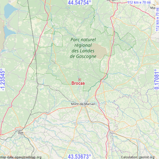
Brocas GPS coordinates[2]
44° 2' 39.444" North, 0° 31' 56.352" West
| Map corner | latitude | longitude |
|---|---|---|
| Upper-left | 44.54754°, | -1.23545° |
| Center: | 44.04429°, | -0.53232° |
| Lower-right: | 43.53673°, | 0.17081° |
| Map W x H: | 112.4×112.4 km | = 69.8×69.8mi |
| max Lat: | 51.07786° ⇑86.7% North |
| Brocas: | 44.04429° |
| min Lat: | ⇓13.3% South 41.3874° |
| min Long | Brocas | max Long |
| -5.08615° | -0.53232° | 9.52242° |
| W 16.2%⇐ | ⇒83.8% E |
Elevation
Elevation of Brocas is 80 m = 262 ft, and this is 113.7 m = 373 ft below average elevation for this country.
| Max E: |
2333 m = 7654 ft | 69.2% |
| Avg. | 193.7 m = 635 ft | |
| Brocas | 80 m = 262 ft | |
Min E: |
-1 m = -3 ft | 30.8% |
See also: France elevation on elevation.city.
Geographical zone
Brocas is located in North temperate zone (between Tropic of Cancer and the Arctic Circle). Distance of this Northern Tropic circle is 2291.3 km =1423.7 mi to South.| Distance of | km | miles | from Brocas |
|---|---|---|---|
| North Pole | 5109.8 | 3175.1 | to North |
| Arctic Circle | 2503.9 | 1555.9 | to North |
| Tropic Cancer | 2291.3 | 1423.7 | to South |
| Equator | 4897.3 | 3043 | to South |


Nearby cities:
15 places around Brocas: (largest is in red/bold)
• Arengosse
21 km =13 mi,  257°
257°
• Bougue
20.5 km =12.7 mi,  146°
146°
• Campagne
21.7 km =13.5 mi,  203°
203°
• Geloux
11.1 km =6.9 mi,  230°
230°
• Labrit
6.9 km =4.3 mi,  351°
351°
• Mont-de-Marsan
17.4 km =10.8 mi,  170°
170°
• Pouydesseaux
18.6 km =11.6 mi,  116°
116°
• Roquefort
16.7 km =10.4 mi,  93°
93°
• Sabres
20.3 km =12.6 mi,  304°
304°
• Saint-Avit
13.4 km =8.3 mi, 149°
• Saint-Perdon
20.4 km =12.7 mi,  193°
193°
• Saint-Pierre-du-Mont
17.8 km =11.1 mi,  177°
177°
• Sarbazan
17.7 km =11 mi,  98°
98°
• Uchacq-et-Parentis
13.2 km =8.2 mi, 189°
• Ygos-Saint-Saturnin
18.1 km =11.2 mi,  245°
245°
Sources, notices
• [Note1] Compared only with cities in France existing in our database
• [Src1] Map data: © OpenStreetMap contributors (CC-BY-SA)
• [Src2] Other city data from geonames.org with taken over terms of usage.
• [Src3] Geographical zone / Annual Mean Temperature by Robert A. Rohde @ Wikipedia
