Bretignolles geodata
Bretignolles (Nouvelle-Aquitaine) is a populated place; located in France in Europe/Paris (GMT+2) time zone. With population of 624 people, there are 12917 cities with bigger population in this country. Compared to other cities in France, 56.5% of cities are located further ↑North; 84.6% of cities are located further →East and 70.4% of cities have lower elevation than Bretignolles. Note1
Administrative division(s):
- Level 1: Nouvelle-Aquitaine
- Level 2: Département des Deux-Sèvres
- Level 3: Arrondissement de Bressuire
- Level 4: Bretignolles


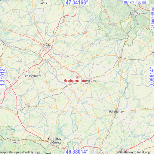
Bretignolles GPS coordinates[2]
46° 51' 46.98" North, 0° 36' 25.164" West
| Map corner | latitude | longitude |
|---|---|---|
| Upper-left | 47.34166°, | -1.31012° |
| Center: | 46.86305°, | -0.60699° |
| Lower-right: | 46.38014°, | 0.09614° |
| Map W x H: | 106.9×106.9 km | = 66.4×66.4mi |
| max Lat: | 51.07786° ⇑56.5% North |
| Bretignolles: | 46.86305° |
| min Lat: | ⇓43.5% South 41.3874° |
| min Long | Bretignolles | max Long |
| -5.08615° | -0.60699° | 9.52242° |
| W 15.4%⇐ | ⇒84.6% E |
Elevation
Elevation of Bretignolles is 221 m = 725 ft, and this is 27.3 m = 90 ft above average elevation for this country.
| Max E: |
2333 m = 7654 ft | 29.6% |
| Bretignolles | 221 m 725 ft | |
| Avg. | 193.7 m = 635 ft | |
Min E: |
-1 m = -3 ft | 70.4% |
See also: France elevation on elevation.city.
Geographical zone
Bretignolles is located in North temperate zone (between Tropic of Cancer and the Arctic Circle). Distance of this North polar circle is 2190.5 km =1361.1 mi to North.| Distance of | km | miles | from Bretignolles |
|---|---|---|---|
| North Pole | 4796.4 | 2980.3 | to North |
| Arctic Circle | 2190.5 | 1361.1 | to North |
| Tropic Cancer | 2604.8 | 1618.5 | to South |
| Equator | 5210.7 | 3237.8 | to South |


Nearby cities:
15 places around Bretignolles: (largest is in red/bold)
• Bressuire
9.2 km =5.7 mi,  105°
105°
• Cerizay
6.4 km =4 mi,  223°
223°
• Chanteloup
12.5 km =7.8 mi,  149°
149°
• Combrand
6.3 km =3.9 mi,  271°
271°
• Courlay
9.8 km =6.1 mi,  162°
162°
• La Forêt-sur-Sèvre
10.9 km =6.8 mi,  197°
197°
• La Petite-Boissière
10.5 km =6.5 mi,  282°
282°
• La Pommeraie-sur-Sèvre
13.4 km =8.3 mi,  256°
256°
• Le Pin
3.7 km =2.3 mi, 269°
• Nueil-les-Aubiers
8 km =5 mi,  12°
12°
• Saint-Amand-sur-Sèvre
14.4 km =8.9 mi, 272°
• Saint-André-sur-Sèvre
10.5 km =6.5 mi,  211°
211°
• Saint-Aubin-du-Plain
12 km =7.5 mi,  55°
55°
• Saint-Mesmin
12.3 km =7.6 mi,  231°
231°
• Voulmentin
11.4 km =7.1 mi,  38°
38°
Sources, notices
• [Note1] Compared only with cities in France existing in our database
• [Src1] Map data: © OpenStreetMap contributors (CC-BY-SA)
• [Src2] Other city data from geonames.org with taken over terms of usage.
• [Src3] Geographical zone / Annual Mean Temperature by Robert A. Rohde @ Wikipedia
