Chanteloup geodata
Chanteloup (Nouvelle-Aquitaine) is a populated place; located in France in Europe/Paris (GMT+2) time zone. With population of 944 people, there are 9259 cities with bigger population in this country. Compared to other cities in France, 57.5% of cities are located further ↑North; 83.7% of cities are located further →East and 69.2% of cities have lower elevation than Chanteloup. Note1
Administrative division(s):
- Level 1: Nouvelle-Aquitaine
- Level 2: Département des Deux-Sèvres
- Level 3: Arrondissement de Bressuire
- Level 4: Chanteloup


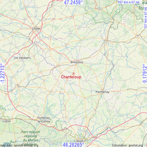
Chanteloup GPS coordinates[2]
46° 45' 59.148" North, 0° 31' 26.4" West
| Map corner | latitude | longitude |
|---|---|---|
| Upper-left | 47.2459°, | -1.22713° |
| Center: | 46.76643°, | -0.524° |
| Lower-right: | 46.28265°, | 0.17912° |
| Map W x H: | 107.1×107.1 km | = 66.5×66.5mi |
| max Lat: | 51.07786° ⇑57.5% North |
| Chanteloup: | 46.76643° |
| min Lat: | ⇓42.5% South 41.3874° |
| min Long | Chanteloup | max Long |
| -5.08615° | -0.524° | 9.52242° |
| W 16.3%⇐ | ⇒83.7% E |
Elevation
Elevation of Chanteloup is 215 m = 705 ft, and this is 21.3 m = 70 ft above average elevation for this country.
| Max E: |
2333 m = 7654 ft | 30.8% |
| Chanteloup | 215 m 705 ft | |
| Avg. | 193.7 m = 635 ft | |
Min E: |
-1 m = -3 ft | 69.2% |
See also: France elevation on elevation.city.
Geographical zone
Chanteloup is located in North temperate zone (between Tropic of Cancer and the Arctic Circle). Distance of this North polar circle is 2201.2 km =1367.8 mi to North.| Distance of | km | miles | from Chanteloup |
|---|---|---|---|
| North Pole | 4807.1 | 2987 | to North |
| Arctic Circle | 2201.2 | 1367.8 | to North |
| Tropic Cancer | 2594 | 1611.8 | to South |
| Equator | 5199.9 | 3231.1 | to South |


Nearby cities:
15 places around Chanteloup: (largest is in red/bold)
• Boismé
6.8 km =4.2 mi,  82°
82°
• Bressuire
8.7 km =5.4 mi,  17°
17°
• Bretignolles
12.5 km =7.8 mi,  329°
329°
• Cerizay
12.4 km =7.7 mi,  299°
299°
• Chiché
13 km =8.1 mi,  74°
74°
• Clessé
10.6 km =6.6 mi,  122°
122°
• Courlay
3.6 km =2.2 mi,  293°
293°
• La Chapelle-Saint-Laurent
4.3 km =2.7 mi, 122°
• La Forêt-sur-Sèvre
9.6 km =6 mi,  272°
272°
• Largeasse
8.3 km =5.2 mi,  167°
167°
• Moncoutant
6.8 km =4.2 mi,  226°
226°
• Moutiers-sous-Chantemerle
10.7 km =6.6 mi,  222°
222°
• Neuvy-Bouin
11.2 km =7 mi,  154°
154°
• Saint-André-sur-Sèvre
12 km =7.5 mi,  278°
278°
• Vernoux-en-Gâtine
14.6 km =9.1 mi,  176°
176°
Sources, notices
• [Note1] Compared only with cities in France existing in our database
• [Src1] Map data: © OpenStreetMap contributors (CC-BY-SA)
• [Src2] Other city data from geonames.org with taken over terms of usage.
• [Src3] Geographical zone / Annual Mean Temperature by Robert A. Rohde @ Wikipedia
