Bressuire geodata
Bressuire (Nouvelle-Aquitaine) is a seat of a third-order administrative division; located in France in Europe/Paris (GMT+2) time zone. With population of 20,743 people, there are 440 cities with bigger population in this country. Compared to other cities in France, 56.7% of cities are located further ↑North; 83.3% of cities are located further →East and 66.2% of cities have lower elevation than Bressuire. Note1
Administrative division(s):
- Level 1: Nouvelle-Aquitaine
- Level 2: Département des Deux-Sèvres
- Level 3: Arrondissement de Bressuire
- Level 4: Bressuire


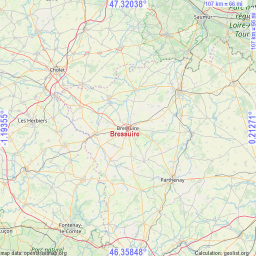
Bressuire GPS coordinates[2]
46° 50' 29.688" North, 0° 29' 25.512" West
| Map corner | latitude | longitude |
|---|---|---|
| Upper-left | 47.32038°, | -1.19355° |
| Center: | 46.84158°, | -0.49042° |
| Lower-right: | 46.35848°, | 0.21271° |
| Map W x H: | 107×107 km | = 66.5×66.5mi |
| max Lat: | 51.07786° ⇑56.7% North |
| Bressuire: | 46.84158° |
| min Lat: | ⇓43.3% South 41.3874° |
| min Long | Bressuire | max Long |
| -5.08615° | -0.49042° | 9.52242° |
| W 16.7%⇐ | ⇒83.3% E |
Elevation
Elevation of Bressuire is 200 m = 656 ft, and this is 6.3 m = 21 ft above average elevation for this country.
| Max E: |
2333 m = 7654 ft | 33.8% |
| Bressuire | 200 m 656 ft | |
| Avg. | 193.7 m = 635 ft | |
Min E: |
-1 m = -3 ft | 66.2% |
See also: France elevation on elevation.city.
Geographical zone
Bressuire is located in North temperate zone (between Tropic of Cancer and the Arctic Circle). Distance of this North polar circle is 2192.9 km =1362.6 mi to North.| Distance of | km | miles | from Bressuire |
|---|---|---|---|
| North Pole | 4798.8 | 2981.8 | to North |
| Arctic Circle | 2192.9 | 1362.6 | to North |
| Tropic Cancer | 2602.4 | 1617.1 | to South |
| Equator | 5208.3 | 3236.3 | to South |


Nearby cities:
15 places around Bressuire: (largest is in red/bold)
• Boismé
8.5 km =5.3 mi,  150°
150°
• Boësse
15 km =9.3 mi,  5°
5°
• Bretignolles
9.2 km =5.7 mi,  285°
285°
• Cerizay
13.5 km =8.4 mi,  260°
260°
• Chanteloup
8.7 km =5.4 mi,  197°
197°
• Chiché
11.1 km =6.9 mi,  116°
116°
• Courlay
9.1 km =5.7 mi,  220°
220°
• Faye-l’Abbesse
10.5 km =6.5 mi,  96°
96°
• La Chapelle-Saint-Laurent
10.7 km =6.6 mi,  174°
174°
• La Forêt-sur-Sèvre
14.5 km =9 mi,  236°
236°
• Le Pin
12.7 km =7.9 mi,  280°
280°
• Moutiers-sous-Argenton
14.6 km =9.1 mi,  30°
30°
• Nueil-les-Aubiers
12.4 km =7.7 mi,  325°
325°
• Saint-Aubin-du-Plain
9.2 km =5.7 mi, 6°
• Voulmentin
11.5 km =7.1 mi,  350°
350°
Sources, notices
• [Note1] Compared only with cities in France existing in our database
• [Src1] Map data: © OpenStreetMap contributors (CC-BY-SA)
• [Src2] Other city data from geonames.org with taken over terms of usage.
• [Src3] Geographical zone / Annual Mean Temperature by Robert A. Rohde @ Wikipedia
