Brannay geodata
Brannay (Bourgogne-Franche-Comté) is a populated place; located in France in Europe/Paris (GMT+2) time zone. With population of 519 people, there are 14840 cities with bigger population in this country. Compared to other cities in France, 63.3% of cities are located further ↓South; 59.5% of cities are located further ←West and 53.3% of cities have lower elevation than Brannay. Note1
Administrative division(s):
- Level 1: Bourgogne-Franche-Comté
- Level 2: Département de l'Yonne
- Level 3: Arrondissement de Sens
- Level 4: Brannay


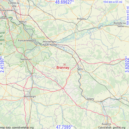
Brannay GPS coordinates[2]
48° 13' 48.108" North, 3° 7' 1.56" East
| Map corner | latitude | longitude |
|---|---|---|
| Upper-left | 48.69627°, | 2.41397° |
| Center: | 48.23003°, | 3.1171° |
| Lower-right: | 47.7595°, | 3.82022° |
| Map W x H: | 104.2×104.2 km | = 64.7×64.7mi |
| max Lat: | 51.07786° ⇑36.7% North |
| Brannay: | 48.23003° |
| min Lat: | ⇓63.3% South 41.3874° |
| min Long | Brannay | max Long |
| -5.08615° | 3.1171° | 9.52242° |
| W 59.5%⇐ | ⇒40.5% E |
Elevation
Elevation of Brannay is 144 m = 472 ft, and this is 49.7 m = 163 ft below average elevation for this country.
| Max E: |
2333 m = 7654 ft | 46.7% |
| Avg. | 193.7 m = 635 ft | |
| Brannay | 144 m = 472 ft | |
Min E: |
-1 m = -3 ft | 53.3% |
See also: France elevation on elevation.city.
Geographical zone
Brannay is located in North temperate zone (between Tropic of Cancer and the Arctic Circle). Distance of this North polar circle is 2038.5 km =1266.7 mi to North.| Distance of | km | miles | from Brannay |
|---|---|---|---|
| North Pole | 4644.4 | 2885.9 | to North |
| Arctic Circle | 2038.5 | 1266.7 | to North |
| Tropic Cancer | 2756.8 | 1713 | to South |
| Equator | 5362.7 | 3332.2 | to South |


Nearby cities:
15 places around Brannay: (largest is in red/bold)
• Blennes
7.6 km =4.7 mi,  293°
293°
• Champigny
9.7 km =6 mi,  7°
7°
• Chaumont
10.2 km =6.3 mi,  355°
355°
• Chéroy
9.3 km =5.8 mi,  249°
249°
• Courtois-sur-Yonne
10.2 km =6.3 mi,  91°
91°
• Cuy
11.4 km =7.1 mi,  74°
74°
• Gisy-les-Nobles
11 km =6.8 mi,  58°
58°
• Montacher-Villegardin
9.4 km =5.8 mi,  221°
221°
• Pont-sur-Yonne
8.6 km =5.3 mi,  46°
46°
• Saint-Denis-lès-Sens
11 km =6.8 mi, 91°
• Saint-Martin-du-Tertre
10.8 km =6.7 mi,  97°
97°
• Saint-Valérien
6 km =3.7 mi,  195°
195°
• Villeblevin
10.8 km =6.7 mi,  345°
345°
• Villemanoche
9.1 km =5.7 mi,  31°
31°
• Villethierry
4.9 km =3 mi,  319°
319°
Sources, notices
• [Note1] Compared only with cities in France existing in our database
• [Src1] Map data: © OpenStreetMap contributors (CC-BY-SA)
• [Src2] Other city data from geonames.org with taken over terms of usage.
• [Src3] Geographical zone / Annual Mean Temperature by Robert A. Rohde @ Wikipedia
