Branges geodata
Branges (Bourgogne-Franche-Comté) is a populated place; located in France in Europe/Paris (GMT+2) time zone. With population of 2,098 people, there are 4596 cities with bigger population in this country. Compared to other cities in France, 58.8% of cities are located further ↑North; 79.6% of cities are located further ←West and 64.4% of cities have lower elevation than Branges. Note1
Administrative division(s):
- Level 1: Bourgogne-Franche-Comté
- Level 2: Département de Saône-et-Loire
- Level 3: Arrondissement de Louhans
- Level 4: Branges


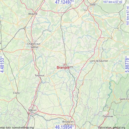
Branges GPS coordinates[2]
46° 38' 39.876" North, 5° 11' 4.74" East
| Map corner | latitude | longitude |
|---|---|---|
| Upper-left | 47.12497°, | 4.48153° |
| Center: | 46.64441°, | 5.18465° |
| Lower-right: | 46.15954°, | 5.88778° |
| Map W x H: | 107.3×107.3 km | = 66.7×66.7mi |
| max Lat: | 51.07786° ⇑58.8% North |
| Branges: | 46.64441° |
| min Lat: | ⇓41.2% South 41.3874° |
| min Long | Branges | max Long |
| -5.08615° | 5.18465° | 9.52242° |
| W 79.6%⇐ | ⇒20.4% E |
Elevation
Elevation of Branges is 191 m = 627 ft, and this is 2.7 m = 9 ft below average elevation for this country.
| Max E: |
2333 m = 7654 ft | 35.6% |
| Avg. | 193.7 m = 635 ft | |
| Branges | 191 m = 627 ft | |
Min E: |
-1 m = -3 ft | 64.4% |
See also: France elevation on elevation.city.
Geographical zone
Branges is located in North temperate zone (between Tropic of Cancer and the Arctic Circle). Distance of this North polar circle is 2214.8 km =1376.2 mi to North.| Distance of | km | miles | from Branges |
|---|---|---|---|
| North Pole | 4820.7 | 2995.4 | to North |
| Arctic Circle | 2214.8 | 1376.2 | to North |
| Tropic Cancer | 2580.5 | 1603.4 | to South |
| Equator | 5186.4 | 3222.7 | to South |


Nearby cities:
15 places around Branges: (largest is in red/bold)
• Baudrières
13.6 km =8.5 mi,  283°
283°
• Bruailles
6.6 km =4.1 mi,  144°
144°
• Frontenaud
13.1 km =8.1 mi, 141°
• Le Fay
11.4 km =7.1 mi,  77°
77°
• Loisy
13.9 km =8.6 mi,  239°
239°
• Louhans
3.7 km =2.3 mi,  123°
123°
• Montpont-en-Bresse
9.9 km =6.2 mi,  188°
188°
• Montret
6.8 km =4.2 mi,  307°
307°
• Rancy
8.8 km =5.5 mi,  233°
233°
• Sagy
10.7 km =6.6 mi, 116°
• Saint-Germain-du-Bois
12.9 km =8 mi,  20°
20°
• Saint-Usuge
6.4 km =4 mi,  52°
52°
• Saint-Étienne-en-Bresse
12.3 km =7.6 mi,  303°
303°
• Simard
8.4 km =5.2 mi,  357°
357°
• Sornay
1.6 km =1 mi, 192°
Sources, notices
• [Note1] Compared only with cities in France existing in our database
• [Src1] Map data: © OpenStreetMap contributors (CC-BY-SA)
• [Src2] Other city data from geonames.org with taken over terms of usage.
• [Src3] Geographical zone / Annual Mean Temperature by Robert A. Rohde @ Wikipedia
