Montpont-en-Bresse geodata
Montpont-en-Bresse (Bourgogne-Franche-Comté) is a populated place; located in France in Europe/Paris (GMT+2) time zone. With population of 1,029 people, there are 8622 cities with bigger population in this country. Compared to other cities in France, 59.6% of cities are located further ↑North; 79.4% of cities are located further ←West and 66.8% of cities have lower elevation than Montpont-en-Bresse. Note1
Administrative division(s):
- Level 1: Bourgogne-Franche-Comté
- Level 2: Département de Saône-et-Loire
- Level 3: Arrondissement de Louhans
- Level 4: Montpont-en-Bresse


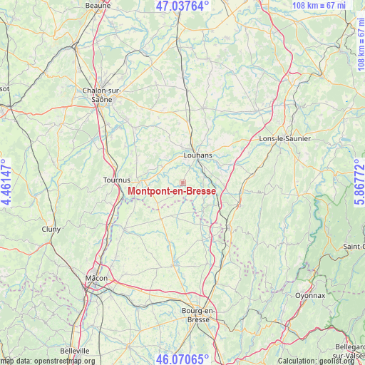
Montpont-en-Bresse GPS coordinates[2]
46° 33' 22.68" North, 5° 9' 52.524" East
| Map corner | latitude | longitude |
|---|---|---|
| Upper-left | 47.03764°, | 4.46147° |
| Center: | 46.5563°, | 5.16459° |
| Lower-right: | 46.07065°, | 5.86772° |
| Map W x H: | 107.5×107.5 km | = 66.8×66.8mi |
| max Lat: | 51.07786° ⇑59.6% North |
| Montpont-en-Bresse: | 46.5563° |
| min Lat: | ⇓40.4% South 41.3874° |
| min Long | Montpont-en-Bre | max Long |
| -5.08615° | 5.16459° | 9.52242° |
| W 79.4%⇐ | ⇒20.6% E |
Elevation
Elevation of Montpont-en-Bresse is 203 m = 666 ft, and this is 9.3 m = 31 ft above average elevation for this country.
| Max E: |
2333 m = 7654 ft | 33.2% |
| Montpont-en-Bresse | 203 m 666 ft | |
| Avg. | 193.7 m = 635 ft | |
Min E: |
-1 m = -3 ft | 66.8% |
See also: France elevation on elevation.city.
Geographical zone
Montpont-en-Bresse is located in North temperate zone (between Tropic of Cancer and the Arctic Circle). Distance of this North polar circle is 2224.6 km =1382.3 mi to North.| Distance of | km | miles | from Montpont-en-Bresse |
|---|---|---|---|
| North Pole | 4830.5 | 3001.5 | to North |
| Arctic Circle | 2224.6 | 1382.3 | to North |
| Tropic Cancer | 2570.7 | 1597.4 | to South |
| Equator | 5176.6 | 3216.6 | to South |


Nearby cities:
15 places around Montpont-en-Bresse: (largest is in red/bold)
• Branges
9.9 km =6.2 mi,  8°
8°
• Bruailles
7 km =4.3 mi,  50°
50°
• Cormoz
13 km =8.1 mi,  157°
157°
• Cuisery
12.7 km =7.9 mi,  270°
270°
• Dommartin-lès-Cuiseaux
12.1 km =7.5 mi,  121°
121°
• Frontenaud
9.8 km =6.1 mi,  92°
92°
• Loisy
10.9 km =6.8 mi,  284°
284°
• Louhans
9 km =5.6 mi,  30°
30°
• Rancy
7.2 km =4.5 mi,  309°
309°
• Romenay
9.5 km =5.9 mi,  230°
230°
• Sagy
12.2 km =7.6 mi,  65°
65°
• Saint-Nizier-le-Bouchoux
10.7 km =6.6 mi,  185°
185°
• Saint-Trivier-de-Courtes
12.6 km =7.8 mi,  211°
211°
• Sornay
8.3 km =5.2 mi, 8°
• Varennes-Saint-Sauveur
10.2 km =6.3 mi,  143°
143°
Sources, notices
• [Note1] Compared only with cities in France existing in our database
• [Src1] Map data: © OpenStreetMap contributors (CC-BY-SA)
• [Src2] Other city data from geonames.org with taken over terms of usage.
• [Src3] Geographical zone / Annual Mean Temperature by Robert A. Rohde @ Wikipedia
