Ettendorf geodata
Ettendorf (Grand Est) is a populated place; located in France in Europe/Paris (GMT+2) time zone. With population of 744 people, there are 11239 cities with bigger population in this country. Compared to other cities in France, 75.8% of cities are located further ↓South; 98.5% of cities are located further ←West and 64.6% of cities have lower elevation than Ettendorf. Note1
Administrative division(s):
- Level 1: Grand Est
- Level 2: Bas-Rhin
- Level 3: Arrondissement de Saverne
- Level 4: Ettendorf


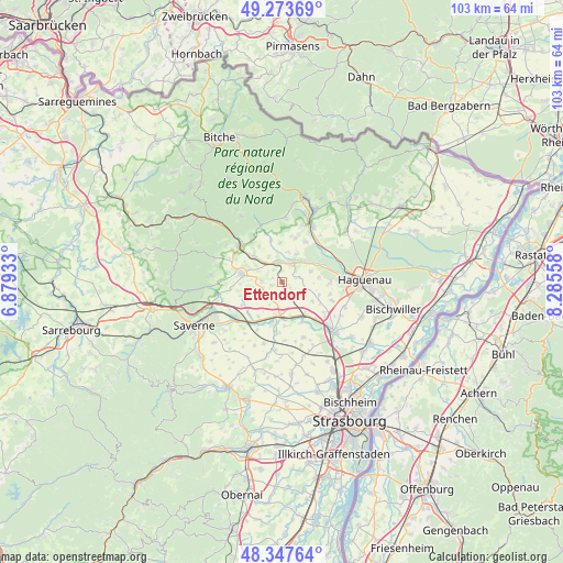
Ettendorf GPS coordinates[2]
48° 48' 46.08" North, 7° 34' 56.82" East
| Map corner | latitude | longitude |
|---|---|---|
| Upper-left | 49.27369°, | 6.87933° |
| Center: | 48.8128°, | 7.58245° |
| Lower-right: | 48.34764°, | 8.28558° |
| Map W x H: | 103×103 km | = 64×64mi |
| max Lat: | 51.07786° ⇑24.2% North |
| Ettendorf: | 48.8128° |
| min Lat: | ⇓75.8% South 41.3874° |
| min Long | Ettendorf | max Long |
| -5.08615° | 7.58245° | 9.52242° |
| W 98.5%⇐ | ⇒1.5% E |
Elevation
Elevation of Ettendorf is 192 m = 630 ft, and this is 1.7 m = 6 ft below average elevation for this country.
| Max E: |
2333 m = 7654 ft | 35.4% |
| Avg. | 193.7 m = 635 ft | |
| Ettendorf | 192 m = 630 ft | |
Min E: |
-1 m = -3 ft | 64.6% |
See also: France elevation on elevation.city.
Geographical zone
Ettendorf is located in North temperate zone (between Tropic of Cancer and the Arctic Circle). Distance of this North polar circle is 1973.7 km =1226.4 mi to North.| Distance of | km | miles | from Ettendorf |
|---|---|---|---|
| North Pole | 4579.6 | 2845.6 | to North |
| Arctic Circle | 1973.7 | 1226.4 | to North |
| Tropic Cancer | 2821.6 | 1753.3 | to South |
| Equator | 5427.5 | 3372.5 | to South |


Nearby cities:
15 places around Ettendorf: (largest is in red/bold)
• Alteckendorf
2.6 km =1.6 mi,  155°
155°
• Bosselshausen
5.4 km =3.4 mi,  260°
260°
• Bouxwiller
7.5 km =4.7 mi,  280°
280°
• Dauendorf
5.7 km =3.5 mi,  70°
70°
• Hochfelden
6.3 km =3.9 mi,  189°
189°
• Kindwiller
5.6 km =3.5 mi,  10°
10°
• Minversheim
4.2 km =2.6 mi,  136°
136°
• Niedermodern
4.8 km =3 mi,  41°
41°
• Obermodern-Zutzendorf
5.5 km =3.4 mi,  319°
319°
• Pfaffenhoffen
3.7 km =2.3 mi,  28°
28°
• Schwindratzheim
6.5 km =4 mi,  169°
169°
• Uberach
5.4 km =3.4 mi, 39°
• Uhlwiller
6.8 km =4.2 mi,  82°
82°
• Uhrwiller
7.3 km =4.5 mi,  357°
357°
• Wittersheim
6.5 km =4 mi,  121°
121°
Sources, notices
• [Note1] Compared only with cities in France existing in our database
• [Src1] Map data: © OpenStreetMap contributors (CC-BY-SA)
• [Src2] Other city data from geonames.org with taken over terms of usage.
• [Src3] Geographical zone / Annual Mean Temperature by Robert A. Rohde @ Wikipedia
