Bourgueil geodata
Bourgueil (Centre) is a populated place; located in France in Europe/Paris (GMT+2) time zone. With population of 4,359 people, there are 2259 cities with bigger population in this country. Compared to other cities in France, 51.8% of cities are located further ↑North; 76.6% of cities are located further →East and 83.1% of cities have higher elevation than Bourgueil. Note1
Administrative division(s):
- Level 1: Centre
- Level 2: Département d'Indre-et-Loire
- Level 3: Arrondissement de Chinon
- Level 4: Bourgueil


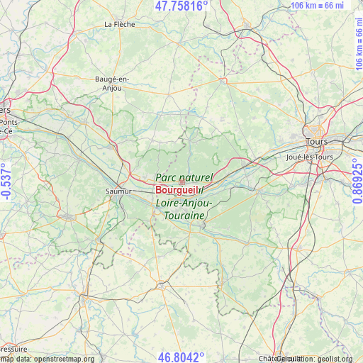
Bourgueil GPS coordinates[2]
47° 16' 59.988" North, 0° 9' 58.032" East
| Map corner | latitude | longitude |
|---|---|---|
| Upper-left | 47.75816°, | -0.537° |
| Center: | 47.28333°, | 0.16612° |
| Lower-right: | 46.8042°, | 0.86925° |
| Map W x H: | 106.1×106.1 km | = 65.9×65.9mi |
| max Lat: | 51.07786° ⇑51.8% North |
| Bourgueil: | 47.28333° |
| min Lat: | ⇓48.2% South 41.3874° |
| min Long | Bourgueil | max Long |
| -5.08615° | 0.16612° | 9.52242° |
| W 23.4%⇐ | ⇒76.6% E |
Elevation
Elevation of Bourgueil is 47 m = 154 ft, and this is 146.7 m = 481 ft below average elevation for this country.
| Max E: |
2333 m = 7654 ft | 83.1% |
| Avg. | 193.7 m = 635 ft | |
| Bourgueil | 47 m = 154 ft | |
Min E: |
-1 m = -3 ft | 16.9% |
See also: France elevation on elevation.city.
Geographical zone
Bourgueil is located in North temperate zone (between Tropic of Cancer and the Arctic Circle). Distance of this North polar circle is 2143.8 km =1332.1 mi to North.| Distance of | km | miles | from Bourgueil |
|---|---|---|---|
| North Pole | 4749.6 | 2951.3 | to North |
| Arctic Circle | 2143.8 | 1332.1 | to North |
| Tropic Cancer | 2651.5 | 1647.6 | to South |
| Equator | 5257.4 | 3266.8 | to South |


Nearby cities:
15 places around Bourgueil: (largest is in red/bold)
• Allonnes
10.7 km =6.6 mi,  275°
275°
• Avoine
8.8 km =5.5 mi,  171°
171°
• Beaumont-en-Véron
10 km =6.2 mi, 172°
• Benais
4.1 km =2.5 mi,  70°
70°
• Brain-sur-Allonnes
7.9 km =4.9 mi,  286°
286°
• Chouzé-sur-Loire
6.1 km =3.8 mi,  211°
211°
• Huismes
8.5 km =5.3 mi,  130°
130°
• Ingrandes-de-Touraine
7.6 km =4.7 mi,  90°
90°
• La Chapelle-sur-Loire
5.4 km =3.4 mi, 132°
• Restigné
4.7 km =2.9 mi, 91°
• Rigny-Ussé
10.7 km =6.6 mi,  108°
108°
• Saint-Nicolas-de-Bourgueil
2.9 km =1.8 mi,  273°
273°
• Saint-Patrice
9.7 km =6 mi, 89°
• Savigny-en-Véron
9.3 km =5.8 mi,  190°
190°
• Varennes-sur-Loire
9.9 km =6.2 mi,  239°
239°
Sources, notices
• [Note1] Compared only with cities in France existing in our database
• [Src1] Map data: © OpenStreetMap contributors (CC-BY-SA)
• [Src2] Other city data from geonames.org with taken over terms of usage.
• [Src3] Geographical zone / Annual Mean Temperature by Robert A. Rohde @ Wikipedia
