Chouzé-sur-Loire geodata
Chouzé-sur-Loire (Centre) is a populated place; located in France in Europe/Paris (GMT+2) time zone. With population of 2,191 people, there are 4384 cities with bigger population in this country. Compared to other cities in France, 52.5% of cities are located further ↑North; 77% of cities are located further →East and 89.5% of cities have higher elevation than Chouzé-sur-Loire. Note1
Administrative division(s):
- Level 1: Centre
- Level 2: Département d'Indre-et-Loire
- Level 3: Arrondissement de Chinon
- Level 4: Chouzé-sur-Loire


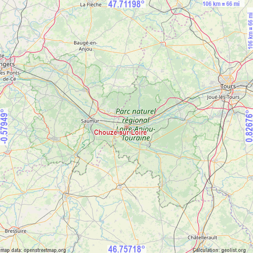
Chouzé-sur-Loire GPS coordinates[2]
47° 14' 12.228" North, 0° 7' 25.104" East
| Map corner | latitude | longitude |
|---|---|---|
| Upper-left | 47.71198°, | -0.57949° |
| Center: | 47.23673°, | 0.12364° |
| Lower-right: | 46.75718°, | 0.82676° |
| Map W x H: | 106.2×106.2 km | = 66×66mi |
| max Lat: | 51.07786° ⇑52.5% North |
| Chouzé-sur-Loire: | 47.23673° |
| min Lat: | ⇓47.5% South 41.3874° |
| min Long | Chouzé-sur-Loi | max Long |
| -5.08615° | 0.12364° | 9.52242° |
| W 23%⇐ | ⇒77% E |
Elevation
Elevation of Chouzé-sur-Loire is 31 m = 102 ft, and this is 162.7 m = 534 ft below average elevation for this country.
| Max E: |
2333 m = 7654 ft | 89.5% |
| Avg. | 193.7 m = 635 ft | |
| Chouzé-sur-Loire | 31 m = 102 ft | |
Min E: |
-1 m = -3 ft | 10.5% |
See also: France elevation on elevation.city.
Geographical zone
Chouzé-sur-Loire is located in North temperate zone (between Tropic of Cancer and the Arctic Circle). Distance of this North polar circle is 2148.9 km =1335.3 mi to North.| Distance of | km | miles | from Chouzé-sur-Loire |
|---|---|---|---|
| North Pole | 4754.8 | 2954.5 | to North |
| Arctic Circle | 2148.9 | 1335.3 | to North |
| Tropic Cancer | 2646.3 | 1644.3 | to South |
| Equator | 5252.2 | 3263.6 | to South |


Nearby cities:
15 places around Chouzé-sur-Loire: (largest is in red/bold)
• Allonnes
9.8 km =6.1 mi,  310°
310°
• Avoine
5.7 km =3.5 mi,  128°
128°
• Beaumont-en-Véron
6.6 km =4.1 mi,  136°
136°
• Benais
9.6 km =6 mi,  47°
47°
• Bourgueil
6.1 km =3.8 mi,  31°
31°
• Brain-sur-Allonnes
8.6 km =5.3 mi,  329°
329°
• Fontevraud-l'Abbaye
8.1 km =5 mi,  223°
223°
• Huismes
9.6 km =6 mi,  92°
92°
• La Chapelle-sur-Loire
7.4 km =4.6 mi,  77°
77°
• Montsoreau
5.2 km =3.2 mi,  243°
243°
• Restigné
9.4 km =5.8 mi,  57°
57°
• Saint-Nicolas-de-Bourgueil
5.4 km =3.4 mi,  2°
2°
• Savigny-en-Véron
4.3 km =2.7 mi,  158°
158°
• Souzay-Champigny
10 km =6.2 mi,  269°
269°
• Varennes-sur-Loire
5.3 km =3.3 mi, 271°
Sources, notices
• [Note1] Compared only with cities in France existing in our database
• [Src1] Map data: © OpenStreetMap contributors (CC-BY-SA)
• [Src2] Other city data from geonames.org with taken over terms of usage.
• [Src3] Geographical zone / Annual Mean Temperature by Robert A. Rohde @ Wikipedia
