Benais geodata
Benais (Centre) is a populated place; located in France in Europe/Paris (GMT+2) time zone. With population of 910 people, there are 9574 cities with bigger population in this country. Compared to other cities in France, 51.6% of cities are located further ↑North; 76.1% of cities are located further →East and 80.6% of cities have higher elevation than Benais. Note1
Administrative division(s):
- Level 1: Centre
- Level 2: Département d'Indre-et-Loire
- Level 3: Arrondissement de Chinon
- Level 4: Benais


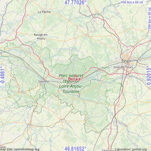
Benais GPS coordinates[2]
47° 17' 43.944" North, 0° 13' 1.308" East
| Map corner | latitude | longitude |
|---|---|---|
| Upper-left | 47.77026°, | -0.4861° |
| Center: | 47.29554°, | 0.21703° |
| Lower-right: | 46.81652°, | 0.92015° |
| Map W x H: | 106×106 km | = 65.9×65.9mi |
| max Lat: | 51.07786° ⇑51.6% North |
| Benais: | 47.29554° |
| min Lat: | ⇓48.4% South 41.3874° |
| min Long | Benais | max Long |
| -5.08615° | 0.21703° | 9.52242° |
| W 23.9%⇐ | ⇒76.1% E |
Elevation
Elevation of Benais is 53 m = 174 ft, and this is 140.7 m = 462 ft below average elevation for this country.
| Max E: |
2333 m = 7654 ft | 80.6% |
| Avg. | 193.7 m = 635 ft | |
| Benais | 53 m = 174 ft | |
Min E: |
-1 m = -3 ft | 19.4% |
See also: France elevation on elevation.city.
Geographical zone
Benais is located in North temperate zone (between Tropic of Cancer and the Arctic Circle). Distance of this North polar circle is 2142.4 km =1331.2 mi to North.| Distance of | km | miles | from Benais |
|---|---|---|---|
| North Pole | 4748.3 | 2950.5 | to North |
| Arctic Circle | 2142.4 | 1331.2 | to North |
| Tropic Cancer | 2652.9 | 1648.4 | to South |
| Equator | 5258.8 | 3267.7 | to South |


Nearby cities:
15 places around Benais: (largest is in red/bold)
• Avoine
10.4 km =6.5 mi,  194°
194°
• Bourgueil
4.1 km =2.5 mi,  250°
250°
• Brain-sur-Allonnes
11.5 km =7.1 mi,  274°
274°
• Bréhémont
10.7 km =6.6 mi,  90°
90°
• Chouzé-sur-Loire
9.6 km =6 mi,  227°
227°
• Huismes
7.4 km =4.6 mi,  159°
159°
• Ingrandes-de-Touraine
4 km =2.5 mi,  109°
109°
• La Chapelle-sur-Loire
5 km =3.1 mi,  178°
178°
• Restigné
1.7 km =1.1 mi,  151°
151°
• Rigny-Ussé
7.9 km =4.9 mi,  127°
127°
• Rivarennes
10.8 km =6.7 mi, 107°
• Saint-Benoît-la-Forêt
11.3 km =7 mi,  135°
135°
• Saint-Michel-sur-Loire
10 km =6.2 mi,  82°
82°
• Saint-Nicolas-de-Bourgueil
6.9 km =4.3 mi,  260°
260°
• Saint-Patrice
5.9 km =3.7 mi,  102°
102°
Sources, notices
• [Note1] Compared only with cities in France existing in our database
• [Src1] Map data: © OpenStreetMap contributors (CC-BY-SA)
• [Src2] Other city data from geonames.org with taken over terms of usage.
• [Src3] Geographical zone / Annual Mean Temperature by Robert A. Rohde @ Wikipedia
